
Topografische Karte Casper
Interaktive Karte
Klicken Sie auf die Karte, um die Höhe anzuzeigen.
Über diese Karte
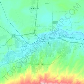
Name: Topografische Karte Casper, Höhe, Relief.
Ort: Casper, Natrona County, Wyoming, United States (42.79129 -106.43497 42.90753 -106.21571)
Durchschnittliche Höhe: 1.635 m
Minimale Höhe: 1.546 m
Maximale Höhe: 2.010 m
Andere topografische Karten
Klicken Sie auf eine Karte, um ihre Topografie, ihre Höhe und ihr Relief anzuzeigen.
Bar Nunn
United States > Wyoming > Natrona County
Bar Nunn, Natrona County, Wyoming, United States
Durchschnittliche Höhe: 1.619 m
Casper
United States > Wyoming > Natrona County > Casper
Casper, Natrona County, Wyoming, 82601, United States
Durchschnittliche Höhe: 1.727 m
Casper Mountain
United States > Wyoming > Natrona County
Casper Mountain, Natrona County, Wyoming, United States
Durchschnittliche Höhe: 2.315 m
Midwest
United States > Wyoming > Natrona County
Midwest, Natrona County, Wyoming, United States
Durchschnittliche Höhe: 1.482 m