
Topografische Karte Perímetro Urbano Villavicencio
Interaktive Karte
Klicken Sie auf die Karte, um die Höhe anzuzeigen.
Über diese Karte
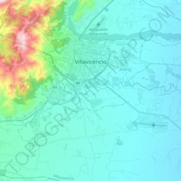
Name: Topografische Karte Perímetro Urbano Villavicencio, Höhe, Relief.
Durchschnittliche Höhe: 473 m
Minimale Höhe: 367 m
Maximale Höhe: 1.188 m
Debido a su cercanía a la línea del ecuador y su baja altitud, comparte el clima monzónico Am, la ciudad tiene un clima cálido con temperaturas desde la mínima 20 °C, hasta la máxima 39 °C, anuales promedio durante el día que van desde 21 hasta 36 grado celsius. La temperatura guarda cierta relación con la precipitación, de manera que los meses más calurosos son aquellos en que la lluvia es menor, en especial febrero y marzo, en los cuales la temperatura máxima sobrepasa en la zona urbana los 35 °C, y los meses más frescos son aquellos considerados como los meses más lluviosos, en enero mayo y julio siendo la temperatura máxima alrededor de 29 y 32 °C.
Andere topografische Karten
Klicken Sie auf eine Karte, um ihre Topografie, ihre Höhe und ihr Relief anzuzeigen.
Villavicencio
Colombia > Meta > Villavicencio
Villavicencio, Meta, Colombia
Durchschnittliche Höhe: 451 m
Montebello
Montebello, Cumaral, Piedemonte, Meta, RAP (Especial) Central, Colombia
Durchschnittliche Höhe: 250 m
Páramo de Sumapaz
Páramo de Sumapaz, Meta, RAP (Especial) Central, Colombia
Durchschnittliche Höhe: 2.122 m
Villavicencio
Colombia > Meta > Villavicencio
Villavicencio, Meta, 500005, Colombia
Durchschnittliche Höhe: 672 m
El Vergel
Colombia > Meta > La Macarena
El Vergel, La Macarena, Ariari, Meta, RAP (Especial) Central, Colombia
Durchschnittliche Höhe: 256 m
Serrania De La Macarena
Colombia > Meta > La Macarena
Serrania De La Macarena, La Macarena, Ariari, Meta, RAP (Especial) Central, Colombia
Durchschnittliche Höhe: 456 m
Nevado del Sumapaz
Nevado del Sumapaz, Guamal, Piedemonte, Meta, RAP (Especial) Central, Colombia
Durchschnittliche Höhe: 3.786 m
Puerto Gaitán
Colombia > Meta > Puerto Gaitán
Puerto Gaitán, Puerto Carreño, Rio Meta, Meta, 86084, Colombia
Durchschnittliche Höhe: 161 m
Parque Nacional Natural Sierra de la Macarena
Parque Nacional Natural Sierra de la Macarena, Meta, Colombia
Durchschnittliche Höhe: 497 m
Caño
Colombia > Meta > La Macarena
Caño, La Macarena, Ariari, Meta, RAP (Especial) Central, Colombia
Durchschnittliche Höhe: 256 m
Puerto Lopez
Puerto Lopez, Rio Meta, Meta, RAP (Especial) Central, Colombia
Durchschnittliche Höhe: 182 m
Caño Amarillo
Colombia > Meta > Vista Hermosa
Caño Amarillo, Vista Hermosa, Ariari, Meta, RAP (Especial) Central, Colombia
Durchschnittliche Höhe: 304 m
Caño Cristales
Colombia > Meta > La Macarena
Caño Cristales, La Macarena, Ariari, Meta, RAP (Especial) Central, Colombia
Durchschnittliche Höhe: 290 m
Sardinata Baja
Sardinata Baja, Acacías, Piedemonte, Meta, RAP (Especial) Central, 507001, Colombia
Durchschnittliche Höhe: 511 m
Caserío Indigena China
Colombia > Meta > Puerto Gaitán
Caserío Indigena China, Puerto Gaitán, Rio Meta, Meta, RAP (Especial) Central, Colombia
Durchschnittliche Höhe: 158 m
Tercer Milenio
Colombia > Meta > Vista Hermosa
Tercer Milenio, Vista Hermosa, Ariari, Meta, Colombia
Durchschnittliche Höhe: 211 m
San Juan de Arama
San Juan de Arama, Ariari, Meta, RAP (Especial) Central, Colombia
Durchschnittliche Höhe: 568 m
Puerto Rico
Colombia > Meta > Puerto Rico > Puerto Rico
Puerto Rico, Ariari, Meta, Colombia
Durchschnittliche Höhe: 214 m
San Luis de Cubarral
Colombia > Meta > San Luis de Cubarral
San Luis de Cubarral, Meta, Colombia
Durchschnittliche Höhe: 608 m
El Cairo
Colombia > Meta > Villavicencio
El Cairo, Villavicencio, Capital, Meta, 500010, Colombia
Durchschnittliche Höhe: 437 m
Castilla La Nueva
Castilla La Nueva, Piedemonte, Meta, Colombia
Durchschnittliche Höhe: 479 m
Puerto Lleras
Puerto Lleras, Ariari, Meta, RAP (Especial) Central, Colombia
Durchschnittliche Höhe: 248 m
San Carlos de Guaroa
San Carlos de Guaroa, Piedemonte, Meta, Colombia
Durchschnittliche Höhe: 234 m
Puerto Gaitán
Puerto Gaitán, Rio Meta, Meta, RAP (Especial) Central, Colombia
Durchschnittliche Höhe: 189 m
Vista Hermosa
Vista Hermosa, Ariari, Meta, RAP (Especial) Central, Colombia
Durchschnittliche Höhe: 353 m
Villavicencio
Colombia > Meta > Villavicencio
Villavicencio, Capital, Meta, Orinoquia, Colombia
Durchschnittliche Höhe: 870 m
El Turpial
Colombia > Meta > La Macarena
El Turpial, La Macarena, Ariari, Meta, Colombia
Durchschnittliche Höhe: 253 m
Barranca de Upía
Barranca de Upía, Piedemonte, Meta, Colombia
Durchschnittliche Höhe: 263 m
Puerto López
Puerto López, Rio Meta, Meta, RAP (Especial) Central, Colombia
Durchschnittliche Höhe: 277 m
La Suiza
Colombia > Meta > Villavicencio
La Suiza, Villavicencio, Capital, Meta, Colombia
Durchschnittliche Höhe: 466 m
Puerto Lleras
Colombia > Meta > Puerto Lleras
Puerto Lleras, Meta, Colombia
Durchschnittliche Höhe: 236 m
Vista Hermosa
Colombia > Meta > Vista Hermosa
Vista Hermosa, Ariari, Meta, Colombia
Durchschnittliche Höhe: 275 m
Parque Nacional Natural Tinigua
Parque Nacional Natural Tinigua, Meta, Colombia
Durchschnittliche Höhe: 375 m
Rio Ariari
Colombia > Meta > Vda. Chinata > Jose Maria
Rio Ariari, LA CRUZ, HUMEDAL, Jose Maria, Vda. Chinata, Meta, Colombia
Durchschnittliche Höhe: 233 m