
Topografische Karte Bray Park
Interaktive Karte
Klicken Sie auf die Karte, um die Höhe anzuzeigen.
Über diese Karte
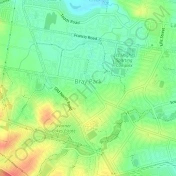
Name: Topografische Karte Bray Park, Höhe, Relief.
Durchschnittliche Höhe: 26 m
Minimale Höhe: 2 m
Maximale Höhe: 60 m
Andere topografische Karten
Klicken Sie auf eine Karte, um ihre Topografie, ihre Höhe und ihr Relief anzuzeigen.
Daintree Rainforest
Daintree Rainforest, Diwan, Douglas Shire, Queensland, Australia
Durchschnittliche Höhe: 59 m
Swan Lake
Australia > Queensland > Gold Coast City
Swan Lake, Burleigh Waters, Gold Coast City, Queensland, Australia
Durchschnittliche Höhe: 6 m
Bartle Frere (North West Peak)
Bartle Frere (North West Peak), Tablelands Regional, Queensland, Australia
Durchschnittliche Höhe: 1.198 m
Victoria Point
Victoria Point, Greater Brisbane, Redland City, Queensland, Australia
Durchschnittliche Höhe: 8 m
Pormpuraaw Aboriginal Shire
Pormpuraaw Aboriginal Shire, Queensland, Australia
Durchschnittliche Höhe: 19 m
Dauan Island
Dauan Island, Torres Strait Island Regional, Queensland, Australia
Durchschnittliche Höhe: 27 m
Yam Island
Yam Island, Iama Island, Torres Strait Island Regional, Queensland, Australia
Durchschnittliche Höhe: 3 m
Doomadgee
Doomadgee, Doomadgee Aboriginal Shire, Queensland, Australia
Durchschnittliche Höhe: 52 m
Kowanyama Aboriginal Shire
Kowanyama Aboriginal Shire, Queensland, Australia
Durchschnittliche Höhe: 11 m
John Handley Community Complex
Australia > Queensland > Gold Coast City
John Handley Community Complex, Burleigh Waters, Gold Coast City, Queensland, Australia
Durchschnittliche Höhe: 4 m
Palm Island
Palm Island, Palm Island Aboriginal Shire, Queensland, Australia
Durchschnittliche Höhe: 7 m
Redbank Plains
Redbank Plains, Greater Brisbane, Queensland, 4301, Australia
Durchschnittliche Höhe: 68 m
Kin Kin
Kin Kin, Noosa Shire, Queensland, 4571, Australia
Durchschnittliche Höhe: 141 m
Mount Coolum
Australia > Queensland > Sunshine Coast Regional
Mount Coolum, Sunshine Coast Regional, Queensland, Australia
Durchschnittliche Höhe: 12 m
Battery Hill
Australia > Queensland > Sunshine Coast Regional
Battery Hill, Sunshine Coast Regional, Queensland, Australia
Durchschnittliche Höhe: 10 m
The Garth
The Garth, Whitsunday Regional, Queensland, Australia
Durchschnittliche Höhe: 191 m
Crestmead
Crestmead, Greater Brisbane, Queensland, 4132, Australia
Durchschnittliche Höhe: 30 m
Sapphire
Sapphire, Central Highlands Regional, Queensland, Australia
Durchschnittliche Höhe: 245 m
Mooloolaba
Australia > Queensland > Sunshine Coast Regional
Mooloolaba, Sunshine Coast Regional, Queensland, Australia
Durchschnittliche Höhe: 7 m
Glenwood
Glenwood, Fraser Coast Regional, Queensland, Australia
Durchschnittliche Höhe: 85 m
Springbrook
Australia > Queensland > Gold Coast City
Springbrook, Gold Coast City, Queensland, 4213, Australia
Durchschnittliche Höhe: 370 m
Magnetic Island
Australia > Queensland > Townsville
Magnetic Island, West Point, Townsville, Townsville City, Queensland, 4819, Australia
Durchschnittliche Höhe: 54 m
Fitzroy Island
Australia > Queensland > Fitzroy Island
Fitzroy Island, Cairns Regional, Queensland, Australia
Durchschnittliche Höhe: 35 m
Pentland
Pentland, Charters Towers Regional, Queensland, Australia
Durchschnittliche Höhe: 411 m
Bundaberg Region
Bundaberg Region, Queensland, Australia
Durchschnittliche Höhe: 70 m
Neglected Mountain
Neglected Mountain, Scenic Rim Regional, Queensland, Australia
Durchschnittliche Höhe: 423 m
Pallarenda
Australia > Queensland > Townsville
Pallarenda, Townsville, Townsville City, Queensland, Australia
Durchschnittliche Höhe: 14 m
Frances
Frances, Hinchinbrook Shire, Queensland, Australia
Durchschnittliche Höhe: 76 m
Daintree National Park
Daintree National Park, Dagmar, Douglas Shire, Queensland, Australia
Durchschnittliche Höhe: 425 m
Warrill View
Warrill View, Scenic Rim Regional, Queensland, Australia
Durchschnittliche Höhe: 82 m
Shelly Beach
Australia > Queensland > Sunshine Coast Regional
Shelly Beach, Sunshine Coast Regional, Queensland, Australia
Durchschnittliche Höhe: 8 m
Armstrong Beach
Armstrong Beach, Mackay Regional, Queensland, Australia
Durchschnittliche Höhe: 10 m
Cherry Creek
Cherry Creek, Toowoomba Regional, Queensland, Australia
Durchschnittliche Höhe: 414 m
Cynthia
Cynthia, North Burnett Regional, Queensland, Australia
Durchschnittliche Höhe: 220 m
Kogan
Kogan, Western Downs Regional, Queensland, Australia
Durchschnittliche Höhe: 344 m
Abergowrie
Abergowrie, Hinchinbrook Shire, Queensland, Australia
Durchschnittliche Höhe: 270 m
Anderleigh
Anderleigh, Gympie Regional, Queensland, Australia
Durchschnittliche Höhe: 121 m
Maryvale
Maryvale, Southern Downs Regional, Queensland, Australia
Durchschnittliche Höhe: 654 m
West End
West End, Greater Brisbane, Queensland, 4101, Australia
Durchschnittliche Höhe: 15 m
Cushnie
Cushnie, South Burnett Regional, Queensland, Australia
Durchschnittliche Höhe: 426 m
Mount Bartle Frere (South Peak)
Mount Bartle Frere (South Peak), Cairns Regional, Queensland, Australia
Durchschnittliche Höhe: 1.276 m
Davies Park
Davies Park, West End, Greater Brisbane, Queensland, 4101, Australia
Durchschnittliche Höhe: 16 m
Riverview
Riverview, Greater Brisbane, Queensland, 4303, Australia
Durchschnittliche Höhe: 28 m
Muttaburra
Muttaburra, Barcaldine Regional, Queensland, 4732, Australia
Durchschnittliche Höhe: 240 m
Ormeau
Australia > Queensland > Gold Coast City
Ormeau, Gold Coast City, Queensland, 4208, Australia
Durchschnittliche Höhe: 24 m
Greenvale
Greenvale, Charters Towers Regional, Queensland, Australia
Durchschnittliche Höhe: 545 m
Irvinebank
Irvinebank, Mareeba Shire, Queensland, Australia
Durchschnittliche Höhe: 710 m
Burdekin River
Burdekin River, Queensland, Australia
Durchschnittliche Höhe: 293 m
Gunalda
Gunalda, Gympie Regional, Queensland, Australia
Durchschnittliche Höhe: 98 m