
Topografische Karte Millanes
Interaktive Karte
Klicken Sie auf die Karte, um die Höhe anzuzeigen.
Über diese Karte
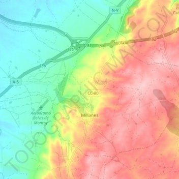
Name: Topografische Karte Millanes, Höhe, Relief.
Ort: Millanes, Campo Arañuelo, Cáceres, Extremadura, España (39.83505 -5.59678 39.87945 -5.52103)
Durchschnittliche Höhe: 358 m
Minimale Höhe: 280 m
Maximale Höhe: 444 m
Andere topografische Karten
Klicken Sie auf eine Karte, um ihre Topografie, ihre Höhe und ihr Relief anzuzeigen.
El Gordo
España > Extremadura > Campo Arañuelo
El Gordo, Campo Arañuelo, Cáceres, Extremadura, 10392, España
Durchschnittliche Höhe: 347 m
Bohonal de Ibor
España > Extremadura > Campo Arañuelo
Bohonal de Ibor, Campo Arañuelo, Cáceres, Extremadura, España
Durchschnittliche Höhe: 388 m
Rosalejo
España > Extremadura > Campo Arañuelo > Rosalejo
Rosalejo, Campo Arañuelo, Cáceres, Extremadura, España
Durchschnittliche Höhe: 278 m
Tiétar
España > Extremadura > Campo Arañuelo > Tiétar
Tiétar, Campo Arañuelo, Cáceres, Extremadura, 10357, España
Durchschnittliche Höhe: 279 m
Casas de Miravete
España > Extremadura > Campo Arañuelo
Casas de Miravete, Campo Arañuelo, Cáceres, Extremadura, España
Durchschnittliche Höhe: 448 m
Navalmoral de la Mata
España > Extremadura > Campo Arañuelo
Navalmoral de la Mata, Campo Arañuelo, Cáceres, Extremadura, 10300, España
Durchschnittliche Höhe: 288 m