
Topografische Karte Billings
Interaktive Karte
Klicken Sie auf die Karte, um die Höhe anzuzeigen.
Über diese Karte
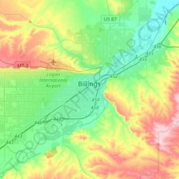
Name: Topografische Karte Billings, Höhe, Relief.
Ort: Billings, Yellowstone County, Montana, United States (45.71067 -108.69152 45.85265 -108.43592)
Durchschnittliche Höhe: 1.023 m
Minimale Höhe: 923 m
Maximale Höhe: 1.219 m
Two-thirds of the city is in the Yellowstone Valley and the South Hills area and one-third in the Heights-Lockwood area. The city is divided by the Rims, long cliffs, also called the Rimrocks. The Rims run to the north and east of the downtown core, separating it from the Heights to the north and Lockwood to the east, with the cliffs to the north being 500 feet (150 m) tall and to the east of downtown, the face rises 800 feet (240 m). Billings elevation is 3,126 feet above sea level. The Yellowstone River runs through the southeast portion of the city. According to the United States Census Bureau, the city has an area of 43.52 square miles (112.72 km2), of which, 43.41 square miles (112.43 km2) is land and 0.11 square miles (0.28 km2) is water.[49]
Andere topografische Karten
Klicken Sie auf eine Karte, um ihre Topografie, ihre Höhe und ihr Relief anzuzeigen.
Baseline
United States > Montana > Yellowstone County
Baseline, Yellowstone County, Montana, 59103, United States
Durchschnittliche Höhe: 1.043 m
Lake Elmo
United States > Montana > Yellowstone County > Billings
Lake Elmo, Billings, Yellowstone County, Montana, United States
Durchschnittliche Höhe: 974 m