
Topografische Karte Satsuma
Interaktive Karte
Klicken Sie auf die Karte, um die Höhe anzuzeigen.
Über diese Karte
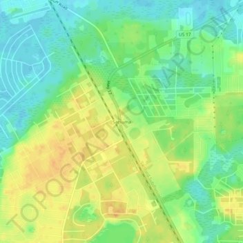
Name: Topografische Karte Satsuma, Höhe, Relief.
Ort: Satsuma, Putnam County, Florida, 32189, United States (29.53497 -81.67591 29.57497 -81.63591)
Durchschnittliche Höhe: 19 m
Minimale Höhe: 3 m
Maximale Höhe: 36 m
Andere topografische Karten
Klicken Sie auf eine Karte, um ihre Topografie, ihre Höhe und ihr Relief anzuzeigen.
Dunns Creek
United States > Florida > Putnam County
Dunns Creek, Putnam County, Florida, 32187, United States
Durchschnittliche Höhe: 7 m
Crescent City
United States > Florida > Putnam County
Crescent City, Putnam County, Florida, United States
Durchschnittliche Höhe: 11 m
Melrose
United States > Florida > Putnam County
Melrose, Putnam County, Florida, 32666, United States
Durchschnittliche Höhe: 45 m
Palatka
United States > Florida > Putnam County
Palatka, Putnam County, Florida, United States
Durchschnittliche Höhe: 8 m
Crossley
United States > Florida > Putnam County > Crossley
Crossley, Putnam County, Florida, United States
Durchschnittliche Höhe: 30 m
Georgetown
United States > Florida > Putnam County > Georgetown
Georgetown, Putnam County, Florida, 32139, United States
Durchschnittliche Höhe: 6 m
Pomona Park
United States > Florida > Putnam County > Pomona Park
Pomona Park, Putnam County, Florida, United States
Durchschnittliche Höhe: 18 m
Interlachen
United States > Florida > Putnam County
Interlachen, Putnam County, Florida, United States
Durchschnittliche Höhe: 31 m