
Topografische Karte Bhubaneshwar
Klicken Sie auf die Karte, um die Höhe anzuzeigen.
Bhubaneshwar
Bhubaneswar is in Khordha district of Odisha. It is in the eastern coastal plains, along the axis of the Eastern Ghats mountains. The city has an average altitude of 45 m (148 ft) above sea level. Bhubaneswar lies in Mahanadi River Delta. The Daya River is 4 km to the south and the Kuakhai River 4 km to the east; the Chandaka Wildlife Sanctuary and Nandankanan Zoo are in west and north to Bhubaneswar, respectively.
Über diese Karte
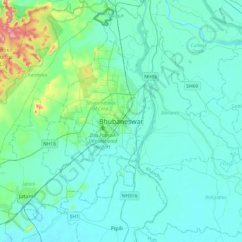
Name: Topografische Karte Bhubaneshwar, Höhe, Relief.
Durchschnittliche Höhe: 30 m
Minimale Höhe: 6 m
Maximale Höhe: 199 m
Andere topografische Karten
Klicken Sie auf eine Karte, um ihre Topografie, ihre Höhe und ihr Relief anzuzeigen.
Ward 44
India > Odisha > Bhubaneswar (M.Corp.) > Bhubaneswar Municipal Corporation
Durchschnittliche Höhe: 21 m
Ward 43
India > Odisha > Bhubaneswar (M.Corp.) > Bhubaneswar Municipal Corporation
Durchschnittliche Höhe: 28 m
Netaji Subash chandra Bose Park
India > Odisha > Bhubaneswar (M.Corp.) > Bhubaneswar Municipal Corporation
Durchschnittliche Höhe: 34 m