Geolokalisieren

Topografische Karte Cruz Quebrada-Dafundo

Klicken Sie auf die Karte, um die Höhe anzuzeigen.

Über diese Karte

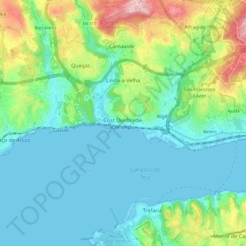
Name: Topografische Karte Cruz Quebrada-Dafundo, Höhe, Relief.

Ort: Cruz Quebrada-Dafundo, Oeiras, Lisboa, 2795-132, Portugal (38.66055 -9.28567 38.74055 -9.20567)

Durchschnittliche Höhe: 54 m

Minimale Höhe: -1 m

Maximale Höhe: 213 m

Andere topografische Karten

Klicken Sie auf eine Karte, um ihre Topografie, ihre Höhe und ihr Relief anzuzeigen.

Avenidas Novas

Portugal > Lisboa > Lisboa

Durchschnittliche Höhe: 85 m

Castelo dos Mouros

Portugal > Lisboa > Sintra

Durchschnittliche Höhe: 276 m

São Domingos de Rana

Portugal > Lisboa

Durchschnittliche Höhe: 91 m

Alvalade

Portugal > Lisboa > Lisboa

Durchschnittliche Höhe: 85 m

Cascais

Portugal > Lisboa > Cascais e Estoril

Durchschnittliche Höhe: 40 m

Encosta do Sol

Portugal > Lisboa

Durchschnittliche Höhe: 109 m

Alcabideche

Portugal > Lisboa

Durchschnittliche Höhe: 143 m

Prazeres

Portugal > Lisboa > Lisboa

Durchschnittliche Höhe: 37 m

Marvila

Portugal > Lisboa > Lisboa

Durchschnittliche Höhe: 51 m

Ribamar

Portugal > Lisboa

Durchschnittliche Höhe: 71 m

Lagoa Azul

Portugal > Lisboa > Sintra

Durchschnittliche Höhe: 248 m

Carrascal de Manique

Portugal > Lisboa > Cascais > São Domingos de Rana

Durchschnittliche Höhe: 119 m

Vermelha

Portugal > Lisboa

Durchschnittliche Höhe: 86 m

Ribeira de Colares

Portugal > Lisboa > Colares

Durchschnittliche Höhe: 57 m

São João das Lampas

Portugal > Lisboa > Sintra

Durchschnittliche Höhe: 98 m

Belém

Portugal > Lisboa > Lisboa

Durchschnittliche Höhe: 53 m

Carvoeira

Portugal > Lisboa > Mafra

Durchschnittliche Höhe: 60 m

Odivelas

Portugal > Lisboa

Durchschnittliche Höhe: 65 m

Abrigada

Portugal > Lisboa > Alenquer

Durchschnittliche Höhe: 153 m

Nossa Senhora de Fátima

Portugal > Lisboa > Lisboa

Durchschnittliche Höhe: 86 m

Forte de Paimogo

Portugal > Lisboa > Lourinhã e Atalaia

Durchschnittliche Höhe: 26 m

Rio de Mouro

Portugal > Lisboa

Durchschnittliche Höhe: 157 m

São José

Portugal > Lisboa > Lisboa > Madalena

Durchschnittliche Höhe: 60 m

Caneças

Portugal > Lisboa > Ramada e Caneças > Caneças

Durchschnittliche Höhe: 259 m

Geomonumento da Rua dos Eucaliptos

Portugal > Lisboa > Lisboa

Durchschnittliche Höhe: 80 m

Sobral de Monte Agraço

Portugal > Lisboa

Durchschnittliche Höhe: 232 m

Barcarena

Portugal > Lisboa > Oeiras

Durchschnittliche Höhe: 108 m

Colares

Portugal > Lisboa

Durchschnittliche Höhe: 145 m

Carnide

Portugal > Lisboa > Lisboa

Durchschnittliche Höhe: 91 m

Miradouro do Monte Agudo

Portugal > Lisboa > Lisboa

Durchschnittliche Höhe: 62 m

Tapada da Ajuda

Portugal > Lisboa > Lisboa

Neste espaço, correspondente a uma antiga tapada real e confinante a norte com o Parque Florestal de Monsanto, encontram-se o Observatório Astronómico de Lisboa, o Instituto Superior de Agronomia, um Pavilhão de Exposições e os campos de jogo de Agronomia (râguebi). No ponto mais alto da Tapada, junto…

Durchschnittliche Höhe: 82 m

Santa Catarina

Portugal > Lisboa > Lisboa

Durchschnittliche Höhe: 44 m

Manique do Intendente

Portugal > Lisboa

Durchschnittliche Höhe: 80 m

Mina de Água

Portugal > Lisboa

Durchschnittliche Höhe: 171 m

Porto Salvo

Portugal > Lisboa > Porto Salvo

Durchschnittliche Höhe: 103 m

Escadas

Portugal > Lisboa > Cascais e Estoril > Cascais

Durchschnittliche Höhe: 25 m

Tapada das Necessidades

Portugal > Lisboa > Lisboa

Durchschnittliche Höhe: 47 m

São João do Estoril

Portugal > Lisboa

Durchschnittliche Höhe: 42 m

Rüsten Sie sich für Ihr nächstes Abenteuer:

🚲Fahrrad GPS - Navigation für Radfahren
🍽️Campinggeschirr - Geschirrset für Outdoor & Trekking
☀️Solar Ladegerät - Energie aus Sonne
🔋Akkus Ersatz - Akkus für Outdoor Geräte
🛏️Schlafsack - Komfortabler Schlafsack für Camping

Als Amazon-Partner verdient diese Website an qualifizierten Käufen, ohne dass Ihnen zusätzliche Kosten entstehen.