
Spenden
Rüsten Sie sich für Ihr nächstes Abenteuer:
Als Amazon-Partner verdient diese Website an qualifizierten Käufen, ohne dass Ihnen zusätzliche Kosten entstehen.
Topografische Karte Pelúgano
Klicken Sie auf die Karte, um die Höhe anzuzeigen.
Spenden
Rüsten Sie sich für Ihr nächstes Abenteuer:
Als Amazon-Partner verdient diese Website an qualifizierten Käufen, ohne dass Ihnen zusätzliche Kosten entstehen.
Über diese Karte
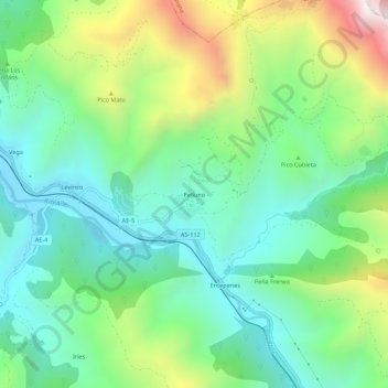
Name: Topografische Karte Pelúgano, Höhe, Relief.
Ort: Pelúgano, Aller, Asturias, 33686, España (43.13136 -5.60341 43.17136 -5.56341)
Durchschnittliche Höhe: 758 m
Minimale Höhe: 436 m
Maximale Höhe: 1.475 m
Spenden
Rüsten Sie sich für Ihr nächstes Abenteuer:
Als Amazon-Partner verdient diese Website an qualifizierten Käufen, ohne dass Ihnen zusätzliche Kosten entstehen.
Andere topografische Karten
Klicken Sie auf eine Karte, um ihre Topografie, ihre Höhe und ihr Relief anzuzeigen.
Casomera
La parroquia tiene una extensión de 67,59 km² y en el año 2021 tenía una población empadronada de 138 habitantes (2021).El lugar de Casomera se halla a 625 metros de altitud y dista 12 km de la villa de Cabañaquinta, capital del concejo.
Durchschnittliche Höhe: 1.336 m
Murias
Es un pueblo agrícola, ganadero (vacuno y caballar) y minero de 81 habitantes (INE 2023), pero hubo un tiempo en que vivían hasta 1000 personas, pero la migración por la falta de trabajo en la zona y el descenso de la natalidad hace que la población rural disminuya notablemente. A los habitantes de Murias…
Durchschnittliche Höhe: 1.199 m
Santibáñez de la Fuente
El lugar de Santibáñez de la Fuente se halla a 575 metros de altitud y en el habitan 57 personas. Se encuentra a unos 8 kilómetros de Cabañaquinta, la capital del concejo.
Durchschnittliche Höhe: 842 m
Spenden
Rüsten Sie sich für Ihr nächstes Abenteuer:
Als Amazon-Partner verdient diese Website an qualifizierten Käufen, ohne dass Ihnen zusätzliche Kosten entstehen.
Murias
Es un pueblo agrícola, ganadero (vacuno y caballar) y minero de 81 habitantes (INE 2023), pero hubo un tiempo en que vivían hasta 1000 personas, pero la migración por la falta de trabajo en la zona y el descenso de la natalidad hace que la población rural disminuya notablemente. A los habitantes de Murias…
Durchschnittliche Höhe: 1.199 m