
Topografische Karte Meudon
Interaktive Karte
Klicken Sie auf die Karte, um die Höhe anzuzeigen.
Über diese Karte
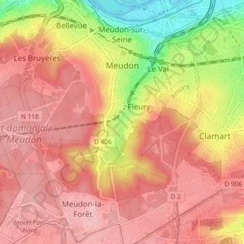
Name: Topografische Karte Meudon, Höhe, Relief.
Durchschnittliche Höhe: 132 m
Minimale Höhe: 28 m
Maximale Höhe: 187 m
The old castle of Meudon was rebuilt in Renaissance style in the mid-sixteenth century. It was bought by Louis XIV as a residence for his son Louis, the Dauphin under whom Meudon became a center of aristocratic life. After the death of the Dauphin in 1711, the château was neglected, emptied in the Revolutionary sales, and finally burned in 1871 at the close of the Franco-Prussian War, while it was occupied by Prussian soldiers. A branch of the Paris Observatory was founded on the ruins in 1877. The Meudon town hall is about 43 m (141.08 ft) in altitude above that of Paris and the climb from there to the observatory offers some rewarding views of Paris.
Andere topografische Karten
Klicken Sie auf eine Karte, um ihre Topografie, ihre Höhe und ihr Relief anzuzeigen.
Le Plessis-Robinson
France > Ile-de-France > Hauts-de-Seine
Le Plessis-Robinson, Antony, Hauts-de-Seine, Ile-de-France, Metropolitan France, 92350, France
Durchschnittliche Höhe: 146 m
Résidence Parc de Béarn
France > Ile-de-France > Hauts-de-Seine > Saint-Cloud
Résidence Parc de Béarn, Saint-Cloud, Arrondissement of Nanterre, Hauts-de-Seine, Ile-de-France, Metropolitan France, 92210, France
Durchschnittliche Höhe: 71 m
Jardin de la Mairie
France > Ile-de-France > Hauts-de-Seine > Boulogne-Billancourt
Jardin de la Mairie, Centre Ville, Boulogne-Billancourt, Hauts-de-Seine, Ile-de-France, Metropolitan France, 92100, France
Durchschnittliche Höhe: 52 m
Quartier Boieldieu
France > Ile-de-France > Hauts-de-Seine > Puteaux
Quartier Boieldieu, Puteaux, Arrondissement of Nanterre, Hauts-de-Seine, Ile-de-France, Metropolitan France, 92800, France
Durchschnittliche Höhe: 52 m
Antony
France > Ile-de-France > Hauts-de-Seine
Antony, Hauts-de-Seine, Ile-de-France, Metropolitan France, 92160, France
Durchschnittliche Höhe: 76 m
Residence Foch
France > Ile-de-France > Hauts-de-Seine > Garches
Residence Foch, Garches, Arrondissement of Nanterre, Hauts-de-Seine, Ile-de-France, Metropolitan France, 92380, France
Durchschnittliche Höhe: 129 m
Bois-Colombes
France > Ile-de-France > Hauts-de-Seine
Bois-Colombes, Arrondissement of Nanterre, Hauts-de-Seine, Ile-de-France, Metropolitan France, 92270, France
Durchschnittliche Höhe: 39 m
Quartier Mont-Valérien
France > Ile-de-France > Hauts-de-Seine > Suresnes
Quartier Mont-Valérien, Suresnes, Arrondissement of Nanterre, Hauts-de-Seine, Ile-de-France, Metropolitan France, 92150, France
Durchschnittliche Höhe: 76 m
Levallois-Perret
France > Ile-de-France > Hauts-de-Seine
Levallois-Perret, Arrondissement of Nanterre, Hauts-de-Seine, Ile-de-France, Metropolitan France, 92300, France
Durchschnittliche Höhe: 40 m
Montrouge
France > Ile-de-France > Hauts-de-Seine
Montrouge, Antony, Hauts-de-Seine, Ile-de-France, Metropolitan France, 92120, France
Durchschnittliche Höhe: 76 m
Puteaux
France > Ile-de-France > Hauts-de-Seine
Puteaux, Arrondissement of Nanterre, Hauts-de-Seine, Ile-de-France, Metropolitan France, 92800, France
Durchschnittliche Höhe: 52 m
Val Saint-Olaf
France > Ile-de-France > Hauts-de-Seine > Chaville > Val Saint-Olaf
Val Saint-Olaf, Chaville, Boulogne-Billancourt, Hauts-de-Seine, Ile-de-France, Metropolitan France, 92370, France
Durchschnittliche Höhe: 128 m
Parc de Billancourt
France > Ile-de-France > Hauts-de-Seine > Boulogne-Billancourt
Parc de Billancourt, Rives de Seine, Boulogne-Billancourt, Hauts-de-Seine, Ile-de-France, Metropolitan France, 92100, France
Durchschnittliche Höhe: 58 m
Clamart
France > Ile-de-France > Hauts-de-Seine > Clamart > Clamart
Clamart, Antony, Hauts-de-Seine, Ile-de-France, Metropolitan France, 92140, France
Durchschnittliche Höhe: 104 m
Villeneuve-la-Garenne
France > Ile-de-France > Hauts-de-Seine > Villeneuve-la-Garenne
Villeneuve-la-Garenne, Arrondissement of Nanterre, Hauts-de-Seine, Ile-de-France, Metropolitan France, 92390, France
Durchschnittliche Höhe: 33 m
Bagneux
France > Ile-de-France > Hauts-de-Seine > Bagneux
Bagneux, Antony, Hauts-de-Seine, Ile-de-France, Metropolitan France, 92220, France
Durchschnittliche Höhe: 91 m
Bois de Boulogne
France > Ile-de-France > Hauts-de-Seine > Neuilly-sur-Seine
Bois de Boulogne, Neuilly-sur-Seine, Arrondissement of Nanterre, Hauts-de-Seine, Ile-de-France, Metropolitan France, 92200, France
Durchschnittliche Höhe: 43 m
Courbevoie
France > Ile-de-France > Hauts-de-Seine
Courbevoie, Arrondissement of Nanterre, Hauts-de-Seine, Ile-de-France, Metropolitan France, 92400, France
Durchschnittliche Höhe: 44 m
Vanves
France > Ile-de-France > Hauts-de-Seine
Vanves, Boulogne-Billancourt, Hauts-de-Seine, Ile-de-France, Metropolitan France, 92170, France
Durchschnittliche Höhe: 67 m
Vaucresson
France > Ile-de-France > Hauts-de-Seine
Vaucresson, Arrondissement of Nanterre, Hauts-de-Seine, Ile-de-France, Metropolitan France, 92420, France
Durchschnittliche Höhe: 157 m
Nanterre
France > Ile-de-France > Hauts-de-Seine > Nanterre
Nanterre, Arrondissement of Nanterre, Hauts-de-Seine, Ile-de-France, Metropolitan France, 92000, France
Durchschnittliche Höhe: 45 m
Boulogne-Billancourt
France > Ile-de-France > Hauts-de-Seine
Boulogne-Billancourt, Hauts-de-Seine, Ile-de-France, Metropolitan France, 92100, France
Durchschnittliche Höhe: 43 m
Neuilly-sur-Seine
France > Ile-de-France > Hauts-de-Seine
Neuilly-sur-Seine, Arrondissement of Nanterre, Hauts-de-Seine, Ile-de-France, Metropolitan France, 92200, France
Durchschnittliche Höhe: 41 m
Malakoff
France > Ile-de-France > Hauts-de-Seine
Malakoff, Antony, Hauts-de-Seine, Ile-de-France, Metropolitan France, 92240, France
Durchschnittliche Höhe: 76 m
Issy-les-Moulineaux
France > Ile-de-France > Hauts-de-Seine
Issy-les-Moulineaux, Boulogne-Billancourt, Hauts-de-Seine, Ile-de-France, Metropolitan France, 92130, France
Durchschnittliche Höhe: 60 m