
Topografische Karte Sorrento Valley
Interaktive Karte
Klicken Sie auf die Karte, um die Höhe anzuzeigen.
Über diese Karte
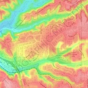
Name: Topografische Karte Sorrento Valley, Höhe, Relief.
Durchschnittliche Höhe: 88 m
Minimale Höhe: 11 m
Maximale Höhe: 134 m
Andere topografische Karten
Klicken Sie auf eine Karte, um ihre Topografie, ihre Höhe und ihr Relief anzuzeigen.
La Jolla
United States > California > San Diego County > San Diego > La Jolla
La Jolla, San Diego, San Diego County, California, 92037, United States
Durchschnittliche Höhe: 37 m
Otay Mesa
United States > California > San Diego County > San Diego
Otay Mesa, San Diego, San Diego County, California, United States
Durchschnittliche Höhe: 112 m
The Carousel
United States > California > San Diego County > San Diego
The Carousel, Mast Boulevard, San Diego, San Diego County, California, 92071, United States
Durchschnittliche Höhe: 137 m
San Diego
United States > California > San Diego County > San Diego
San Diego, San Diego County, California, 92101, United States
Durchschnittliche Höhe: 57 m
Emerald Hills
United States > California > San Diego County > San Diego > Emerald Hills
Emerald Hills, San Diego, San Diego County, California, 92102-4810, United States
Durchschnittliche Höhe: 74 m