
Topografische Karte Thousand Oaks
Interaktive Karte
Klicken Sie auf die Karte, um die Höhe anzuzeigen.
Über diese Karte
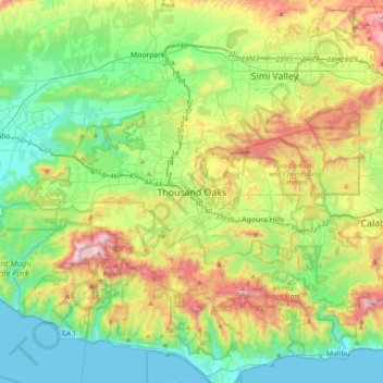
Name: Topografische Karte Thousand Oaks, Höhe, Relief.
Durchschnittliche Höhe: 288 m
Minimale Höhe: 0 m
Maximale Höhe: 918 m
Andere topografische Karten
Klicken Sie auf eine Karte, um ihre Topografie, ihre Höhe und ihr Relief anzuzeigen.
Thousand Oaks
United States > California > Ventura County > Thousand Oaks
Thousand Oaks, Ventura County, California, United States
Durchschnittliche Höhe: 303 m
Newbury Park
United States > California > Ventura County > Thousand Oaks
Newbury Park, Thousand Oaks, Ventura County, CAL Fire Southern Region, California, 91320, United States
Durchschnittliche Höhe: 262 m
Greenwich Village
United States > California > Ventura County > Thousand Oaks
Greenwich Village, Thousand Oaks, Ventura County, CAL Fire Southern Region, California, 91360, United States
Durchschnittliche Höhe: 275 m
Westlake Village
United States > California > Ventura County > Thousand Oaks
Westlake Village, Thousand Oaks, Ventura County, CAL Fire Southern Region, California, 91361, United States
Durchschnittliche Höhe: 305 m
Ventu Park
United States > California > Ventura County > Thousand Oaks > Newbury Park
Ventu Park, Newbury Park, Thousand Oaks, Ventura County, CAL Fire Southern Region, California, 91320, United States
Durchschnittliche Höhe: 250 m