
Spenden
Rüsten Sie sich für Ihr nächstes Abenteuer:
Als Amazon-Partner verdient diese Website an qualifizierten Käufen, ohne dass Ihnen zusätzliche Kosten entstehen.
Topografische Karte Penticton
Klicken Sie auf die Karte, um die Höhe anzuzeigen.
Spenden
Rüsten Sie sich für Ihr nächstes Abenteuer:
Als Amazon-Partner verdient diese Website an qualifizierten Käufen, ohne dass Ihnen zusätzliche Kosten entstehen.
Penticton
Penticton is located at the geographical coordinates of 49°29′28″N 119°35′19″W / 49.49111°N 119.58861°W / 49.49111; -119.58861 (Penticton) and covers an area of 42.10 km2 (16.25 sq mi), with a maximum north–south distance of 7 km (4.3 mi) wide between the Okanagan Lake to the north and Skaha Lake to the south; these lakes are part of the drainage system of the Okanagan River, a tributary of the Columbia River. Its borders are formed by Skaha Lake Road to the south and west, which changes to Highway 97 after city limits, Naramata Road to the east, and to the west, Highway 97. Penticton has an elevation of 385 m (1,263 ft), and is situated five hours from Seattle, Washington, or Vancouver, British Columbia, and eight hours from Calgary, Alberta, by highway.
Spenden
Rüsten Sie sich für Ihr nächstes Abenteuer:
Als Amazon-Partner verdient diese Website an qualifizierten Käufen, ohne dass Ihnen zusätzliche Kosten entstehen.
Über diese Karte
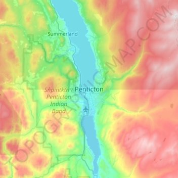
Name: Topografische Karte Penticton, Höhe, Relief.
Durchschnittliche Höhe: 1.044 m
Minimale Höhe: 333 m
Maximale Höhe: 2.131 m
Spenden
Rüsten Sie sich für Ihr nächstes Abenteuer:
Als Amazon-Partner verdient diese Website an qualifizierten Käufen, ohne dass Ihnen zusätzliche Kosten entstehen.