
Topografische Karte Lalin
Interaktive Karte
Klicken Sie auf die Karte, um die Höhe anzuzeigen.
Über diese Karte
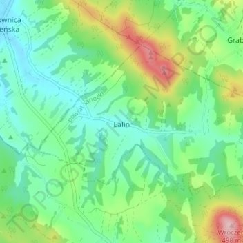
Name: Topografische Karte Lalin, Höhe, Relief.
Durchschnittliche Höhe: 350 m
Minimale Höhe: 289 m
Maximale Höhe: 494 m
Andere topografische Karten
Klicken Sie auf eine Karte, um ihre Topografie, ihre Höhe und ihr Relief anzuzeigen.
Sanok
Poland > Subcarpathian Voivodeship > Sanok County > Sanok
Sanok, Sanok County, Subcarpathian Voivodeship, Poland
Durchschnittliche Höhe: 354 m
Falejówka
Poland > Subcarpathian Voivodeship > Sanok County
Falejówka, gmina Sanok, Sanok County, Subcarpathian Voivodeship, Poland
Durchschnittliche Höhe: 379 m
Komańcza
Poland > Subcarpathian Voivodeship > Sanok County
Komańcza, gmina Komańcza, Sanok County, Subcarpathian Voivodeship, Poland
Durchschnittliche Höhe: 564 m