
Topografische Karte Saül
Interaktive Karte
Klicken Sie auf die Karte, um die Höhe anzuzeigen.
Über diese Karte
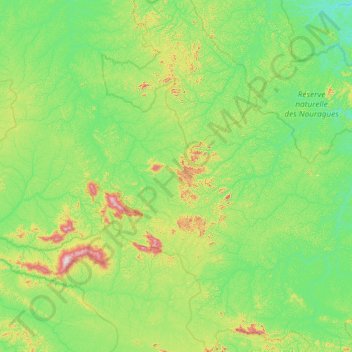
Name: Topografische Karte Saül, Höhe, Relief.
Durchschnittliche Höhe: 161 m
Minimale Höhe: 17 m
Maximale Höhe: 805 m
Andere topografische Karten
Klicken Sie auf eine Karte, um ihre Topografie, ihre Höhe und ihr Relief anzuzeigen.
Crique Gaan Daaye
France > French Guiana > Papaichton
Crique Gaan Daaye, Papaichton, Saint-Laurent-du-Maroni, French Guiana, 97316, France
Durchschnittliche Höhe: 287 m
Masikili Iwɨtɨ
France > French Guiana > Camopi
Masikili Iwɨtɨ, Camopi, Arrondissement de Saint-Georges, French Guiana, 97330, France
Durchschnittliche Höhe: 93 m
Plateau à l'Est
France > French Guiana > Saül
Plateau à l'Est, Saül, Arrondissement de Saint-Laurent-du-Maroni, French Guiana, 97314, France
Durchschnittliche Höhe: 224 m
Remire-Montjoly
Remire-Montjoly, Arrondissement de Cayenne, French Guiana, 97354, France
Durchschnittliche Höhe: 18 m
Cayenne
France > French Guiana > Cayenne
Cayenne, Arrondissement de Cayenne, French Guiana, 97300, France
Durchschnittliche Höhe: 1 m
Kãyɨlalɨ
Kãyɨlalɨ, Yawalu, Cayenne, French Guiana, France
Durchschnittliche Höhe: 111 m
Matoury
France > French Guiana > Matoury
Matoury, Cayenne, French Guiana, 97351, France
Durchschnittliche Höhe: 11 m
Tampak
France > French Guiana > Camopi
Tampak, Camopi, Cayenne, French Guiana, 97330, France
Durchschnittliche Höhe: 104 m
Kourou
France > French Guiana > Kourou
Kourou, Cayenne, French Guiana, 97310, France
Durchschnittliche Höhe: 35 m