
Topografische Karte Belknap County
Interaktive Karte
Klicken Sie auf die Karte, um die Höhe anzuzeigen.
Über diese Karte
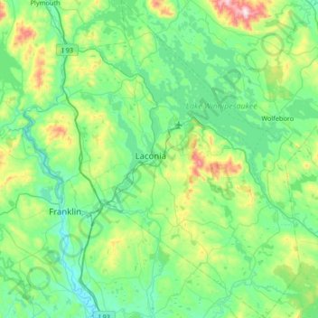
Name: Topografische Karte Belknap County, Höhe, Relief.
Ort: Belknap County, New Hampshire, United States of America (43.28472 -71.73172 43.76503 -71.16013)
Durchschnittliche Höhe: 229 m
Minimale Höhe: 74 m
Maximale Höhe: 891 m
Andere topografische Karten
Klicken Sie auf eine Karte, um ihre Topografie, ihre Höhe und ihr Relief anzuzeigen.
Connecticut River
United States of America > New Hampshire > Cornish
Connecticut River, Cornish, Sullivan County, New Hampshire, 05902, United States of America
Durchschnittliche Höhe: 264 m
Marlow
United States of America > New Hampshire > Marlow
Marlow, Cheshire County, New Hampshire, 03456, United States of America
Durchschnittliche Höhe: 446 m
South Wolfeboro
United States of America > New Hampshire > Wolfeboro > South Wolfeboro
South Wolfeboro, Wolfeboro, Carroll County, New Hampshire, 03894, United States of America
Durchschnittliche Höhe: 197 m
Farmington
United States of America > New Hampshire > Farmington
Farmington, Strafford County, New Hampshire, 03835, United States of America
Durchschnittliche Höhe: 168 m
Darkstar Glades
United States of America > New Hampshire > Francestown
Darkstar Glades, Out-of-Bounds, Francestown, Hillsborough County, New Hampshire, 03403, United States of America
Durchschnittliche Höhe: 402 m
Candia
United States of America > New Hampshire > Candia
Candia, Rockingham County, New Hampshire, 03034, United States of America
Durchschnittliche Höhe: 127 m