Geolokalisieren

Topografische Karte Lotissement du Golf

Interaktive Karte

Klicken Sie auf die Karte, um die Höhe anzuzeigen.

Über diese Karte

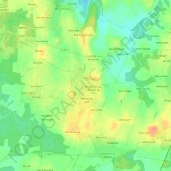
Name: Topografische Karte Lotissement du Golf, Höhe, Relief.

Ort: Lotissement du Golf, Ploemel, Lorient, Morbihan, Bretagne, France métropolitaine, 56400, France (47.63904 -3.12630 47.67904 -3.08630)

Durchschnittliche Höhe: 23 m

Minimale Höhe: 3 m

Maximale Höhe: 46 m

Andere topografische Karten

Klicken Sie auf eine Karte, um ihre Topografie, ihre Höhe und ihr Relief anzuzeigen.

La Villeneuve

France > Bretagne > Morbihan > Ploemel

La Villeneuve, Ploemel, Lorient, Morbihan, Bretagne, France métropolitaine, 56400, France

Durchschnittliche Höhe: 23 m

Locmiquel

France > Bretagne > Morbihan > Ploemel

Locmiquel, Ploemel, Lorient, Morbihan, Bretagne, France métropolitaine, 56400, France

Durchschnittliche Höhe: 24 m

Pax

France > Bretagne > Morbihan > Ploemel > Pax

Pax, Ploemel, Lorient, Morbihan, Bretagne, France métropolitaine, 56400, France

Durchschnittliche Höhe: 23 m

Er Grah

France > Bretagne > Morbihan > Ploemel

Er Grah, Ploemel, Lorient, Morbihan, Bretagne, France métropolitaine, 56400, France

Durchschnittliche Höhe: 23 m

Kerivallan

France > Bretagne > Morbihan > Ploemel

Kerivallan, Ploemel, Lorient, Morbihan, Bretagne, France métropolitaine, 56400, France

Durchschnittliche Höhe: 23 m

Kergounio

France > Bretagne > Morbihan > Ploemel

Kergounio, Ploemel, Lorient, Morbihan, Bretagne, France métropolitaine, 56400, France

Durchschnittliche Höhe: 24 m