
Topografische Karte Encañada
Interaktive Karte
Klicken Sie auf die Karte, um die Höhe anzuzeigen.
Über diese Karte
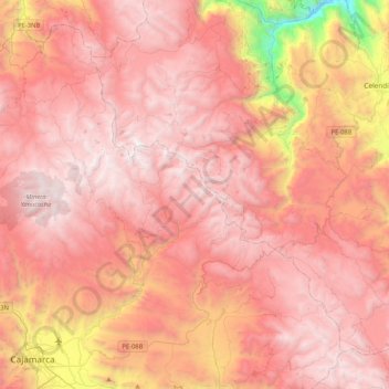
Name: Topografische Karte Encañada, Höhe, Relief.
Ort: Encañada, Province of Cajamarca, Cajamarca, Peru (-7.16532 -78.60175 -6.79894 -78.18369)
Durchschnittliche Höhe: 3.421 m
Minimale Höhe: 1.518 m
Maximale Höhe: 4.244 m
One of the highest elevations of the district is the Llusk'a Qullpa mountain range at approximately 4,000 m (13,000 ft) on the border with the Namora District. Other mountains are listed below:
Andere topografische Karten
Klicken Sie auf eine Karte, um ihre Topografie, ihre Höhe und ihr Relief anzuzeigen.
Province of San Marcos
Province of San Marcos, Cajamarca, 06321, Peru
Durchschnittliche Höhe: 2.783 m
Bambamarca
Bambamarca, Province of Hualgayoc, Cajamarca, Peru
Durchschnittliche Höhe: 3.247 m
Province of San Pablo
Province of San Pablo, Cajamarca, Peru
Durchschnittliche Höhe: 2.959 m
Province of San Marcos
Peru > Cajamarca > José Sabogal
Province of San Marcos, José Sabogal, San Marcos, Cajamarca, Peru
Durchschnittliche Höhe: 3.865 m