
Topografische Karte Clark Fork
Interaktive Karte
Klicken Sie auf die Karte, um die Höhe anzuzeigen.
Über diese Karte
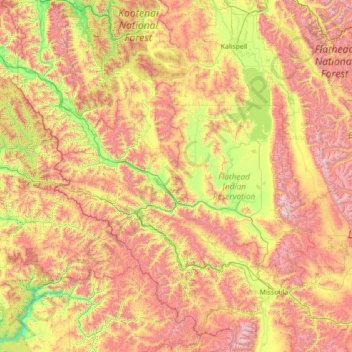
Name: Topografische Karte Clark Fork, Höhe, Relief.
Durchschnittliche Höhe: 1.345 m
Minimale Höhe: 465 m
Maximale Höhe: 2.924 m
Andere topografische Karten
Klicken Sie auf eine Karte, um ihre Topografie, ihre Höhe und ihr Relief anzuzeigen.
Makoshika State Park
United States of America > Montana
Makoshika State Park, Dawson County, Montana, United States of America
Durchschnittliche Höhe: 741 m
Cooke City-Silver Gate
United States of America > Montana > Cooke City-Silver Gate
Cooke City-Silver Gate, Park County, Montana, United States of America
Durchschnittliche Höhe: 2.686 m
Tongue River
United States of America > Montana
Tongue River, Rosebud County, Montana, 59012, United States of America
Durchschnittliche Höhe: 1.050 m
Gallatin Gateway
United States of America > Montana > Gallatin Gateway
Gallatin Gateway, Gallatin County, Montana, United States of America
Durchschnittliche Höhe: 1.519 m
Lewis & Clark Caverns State Park
United States of America > Montana
Lewis & Clark Caverns State Park, 25, Jefferson County, Montana, 59759, United States of America
Durchschnittliche Höhe: 1.496 m
Square Butte
United States of America > Montana
Square Butte, Daniels County, Montana, United States of America
Durchschnittliche Höhe: 830 m
Hyalite Creek
United States of America > Montana
Hyalite Creek, Gallatin County, Montana, 59714, United States of America
Durchschnittliche Höhe: 1.355 m
Lustre
United States of America > Montana > Lustre
Lustre, Valley County, Montana, United States of America
Durchschnittliche Höhe: 845 m
Beaverhead Rock
United States of America > Montana
Beaverhead Rock, Madison County, Montana, United States of America
Durchschnittliche Höhe: 1.492 m
Atkins
United States of America > Montana > Atkins
Atkins, Gallatin County, Montana, United States of America
Durchschnittliche Höhe: 1.490 m
Joplin
United States of America > Montana > Joplin
Joplin, Liberty County, Montana, United States of America
Durchschnittliche Höhe: 1.011 m
Chicory
United States of America > Montana > Chicory
Chicory, Park County, Montana, United States of America
Durchschnittliche Höhe: 1.511 m
Earthquake Lake
United States of America > Montana > Cliff Lake
Earthquake Lake, US 287, Cliff Lake, Madison County, Montana, United States of America
Durchschnittliche Höhe: 2.329 m
Larslan
United States of America > Montana > Larslan
Larslan, Valley County, Montana, United States of America
Durchschnittliche Höhe: 890 m
Fort Belknap Agency
United States of America > Montana
Fort Belknap Agency, Blaine County, Montana, 59526, United States of America
Durchschnittliche Höhe: 746 m
Mount Frazier
United States of America > Montana
Mount Frazier, Teton County, Montana, United States of America
Durchschnittliche Höhe: 2.042 m
Medicine Rocks State Park
United States of America > Montana
Medicine Rocks State Park, Carter County, Montana, United States of America
Durchschnittliche Höhe: 1.021 m
Monarch
United States of America > Montana > Monarch
Monarch, Cascade County, Montana, 59463, United States of America
Durchschnittliche Höhe: 1.548 m
Ashland
United States of America > Montana > Ashland
Ashland, Rosebud County, Montana, 59003, United States of America
Durchschnittliche Höhe: 940 m
Threemile Buttes
United States of America > Montana
Threemile Buttes, Powder River County, Montana, United States of America
Durchschnittliche Höhe: 1.216 m
Saypo
United States of America > Montana > Saypo
Saypo, Teton County, Montana, United States of America
Durchschnittliche Höhe: 1.425 m
Porters Corner
United States of America > Montana > Porters Corner
Porters Corner, Granite County, Montana, United States of America
Durchschnittliche Höhe: 1.679 m