
Topografische Karte Camiling
Interaktive Karte
Klicken Sie auf die Karte, um die Höhe anzuzeigen.
Über diese Karte
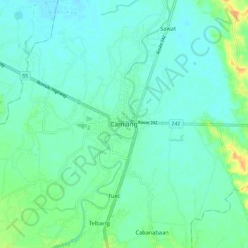
Name: Topografische Karte Camiling, Höhe, Relief.
Ort: Camiling, Tarlac, Central Luzon, 2306, Philippines (15.64638 120.37468 15.72638 120.45468)
Durchschnittliche Höhe: 19 m
Minimale Höhe: 10 m
Maximale Höhe: 47 m
Mostly of plain topography but some parts are hilly to mountainous in which the barangays of Papaac, Bacsay, Birbira and Cayasan, to name a few. The deeper part of the mountains can be described as a place where wild animals live, such as deer, Toddy cat (Musang), wild boar (Baboy ramo), Monitor lizard (Bayawak).
Andere topografische Karten
Klicken Sie auf eine Karte, um ihre Topografie, ihre Höhe und ihr Relief anzuzeigen.
Poblacion A
Philippines > Tarlac > Camiling
Poblacion A, Camiling, Tarlac, Central Luzon, 2306, Philippines
Durchschnittliche Höhe: 17 m