
Topografische Karte Bawi
Interaktive Karte
Klicken Sie auf die Karte, um die Höhe anzuzeigen.
Über diese Karte
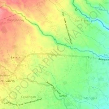
Name: Topografische Karte Bawi, Höhe, Relief.
Ort: Bawi, Padre Garcia, Batangas, Calabarzon, 4224, Philippines (13.86712 121.21289 13.90712 121.25289)
Durchschnittliche Höhe: 156 m
Minimale Höhe: 111 m
Maximale Höhe: 202 m
Andere topografische Karten
Klicken Sie auf eine Karte, um ihre Topografie, ihre Höhe und ihr Relief anzuzeigen.
Quilo-quilo North
Philippines > Batangas > Padre Garcia
Quilo-quilo North, Padre Garcia, Batangas, Calabarzon, 4224, Philippines
Durchschnittliche Höhe: 152 m
San Miguel
Philippines > Batangas > Padre Garcia
San Miguel, Padre Garcia, Batangas, Calabarzon, 4224, Philippines
Durchschnittliche Höhe: 181 m
Padre Garcia
Philippines > Batangas > Padre Garcia
Padre Garcia, Batangas, Calabarzon, 4224, Philippines
Durchschnittliche Höhe: 172 m
San Felipe
Philippines > Batangas > Padre Garcia
San Felipe, Padre Garcia, Batangas, Calabarzon, 4224, Philippines
Durchschnittliche Höhe: 189 m
Pansol
Philippines > Batangas > Padre Garcia
Pansol, Padre Garcia, Batangas, Calabarzon, 4224, Philippines
Durchschnittliche Höhe: 136 m
Banaba
Philippines > Batangas > Padre Garcia
Banaba, Padre Garcia, Batangas, Calabarzon, 4224, Philippines
Durchschnittliche Höhe: 174 m