
Topografische Karte Omi
Interaktive Karte
Klicken Sie auf die Karte, um die Höhe anzuzeigen.
Über diese Karte
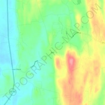
Name: Topografische Karte Omi, Höhe, Relief.
Durchschnittliche Höhe: 93 m
Minimale Höhe: 55 m
Maximale Höhe: 153 m
Andere topografische Karten
Klicken Sie auf eine Karte, um ihre Topografie, ihre Höhe und ihr Relief anzuzeigen.
Pulvers
United States > New York > Columbia County > Town of Ghent
Pulvers, Town of Ghent, Columbia County, New York, 12075, United States
Durchschnittliche Höhe: 111 m
Arnolds Mill
United States > New York > Columbia County > Town of Ghent
Arnolds Mill, Town of Ghent, Columbia County, New York, 12037, United States
Durchschnittliche Höhe: 178 m
West Ghent
United States > New York > Columbia County > Town of Ghent
West Ghent, Town of Ghent, Columbia County, New York, 12174, United States
Durchschnittliche Höhe: 72 m
Buckleyville
United States > New York > Columbia County > Town of Ghent
Buckleyville, Town of Ghent, Columbia County, New York, 12037, United States
Durchschnittliche Höhe: 157 m