
Topografische Karte Lowertown
Interaktive Karte
Klicken Sie auf die Karte, um die Höhe anzuzeigen.
Über diese Karte
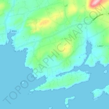
Name: Topografische Karte Lowertown, Höhe, Relief.
Ort: Lowertown, West Cork, County Cork, Munster, Irland (51.48314 -9.64389 51.53591 -9.58401)
Durchschnittliche Höhe: 29 m
Minimale Höhe: -3 m
Maximale Höhe: 190 m
Andere topografische Karten
Klicken Sie auf eine Karte, um ihre Topografie, ihre Höhe und ihr Relief anzuzeigen.
Milltown North
Irland > County Limerick > The Municipal District of Adare — Rathkeale
Milltown North, Lismakeery, The Municipal District of Adare — Rathkeale, County Limerick, Munster, Irland
Durchschnittliche Höhe: 22 m
Glencullen ED
Glencullen ED, Dublin 18, Dún Laoghaire-Rathdown, County Dublin, Leinster, Irland
Durchschnittliche Höhe: 137 m
Killaan ED
Killaan ED, New Inn, County Galway, Connacht, Irland
Durchschnittliche Höhe: 92 m
Clontarf West
Clontarf West, Clontarf West C ED, Dublin 3, Dublin, County Dublin, Leinster, Irland
Durchschnittliche Höhe: 15 m
Townparks
Irland > Cathair na Gaillimhe > Galway Municipal District
Townparks, St Nicholas, Galway Municipal District, Cathair na Gaillimhe, County Galway, Connacht, Irland
Durchschnittliche Höhe: 7 m
North Bull Island
North Bull Island, Raheny St. Assam ED, Dublin 5, Dublin, County Dublin, Leinster, Irland
Durchschnittliche Höhe: 2 m