
Topografische Karte Tenango
Interaktive Karte
Klicken Sie auf die Karte, um die Höhe anzuzeigen.
Über diese Karte
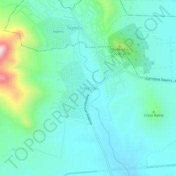
Name: Topografische Karte Tenango, Höhe, Relief.
Ort: Tenango, Tezontepec de Aldama, Hidalgo, México (20.20713 -99.30737 20.24713 -99.26737)
Durchschnittliche Höhe: 2.080 m
Minimale Höhe: 1.964 m
Maximale Höhe: 2.558 m
Andere topografische Karten
Klicken Sie auf eine Karte, um ihre Topografie, ihre Höhe und ihr Relief anzuzeigen.
Huitel
México > Hidalgo > Tezontepec de Aldama
Huitel, Tezontepec de Aldama, Hidalgo, 42764, México
Durchschnittliche Höhe: 2.032 m
Santa María Batha
México > Hidalgo > Tezontepec de Aldama > Santa María Batha
Santa María Batha, Tezontepec de Aldama, Hidalgo, 42700, México
Durchschnittliche Höhe: 1.997 m
Cerro Xicuco
México > Hidalgo > Tezontepec de Aldama
Cerro Xicuco, Tezontepec de Aldama, Hidalgo, México
Durchschnittliche Höhe: 2.117 m