
Topografische Karte Schnecksville
Interaktive Karte
Klicken Sie auf die Karte, um die Höhe anzuzeigen.
Schnecksville
According to the U.S. Census Bureau, Schnecksville has a total area of 2.7 square miles (7.0 km2), of which 0.01 square miles (0.02 km2), or 0.28%, are water. Schnecksville sits on a ridge at an elevation of about 660 feet (200 m) above sea level. To the west, water flows to Jordan Creek, while to the east water flows to Coplay Creek. Both creeks are southeast-flowing tributaries of the Lehigh River and part of the Delaware River watershed.
Über diese Karte
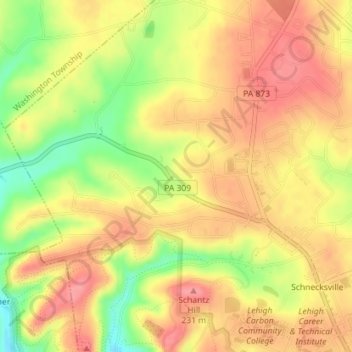
Name: Topografische Karte Schnecksville, Höhe, Relief.
Durchschnittliche Höhe: 197 m
Minimale Höhe: 144 m
Maximale Höhe: 229 m
Andere topografische Karten
Klicken Sie auf eine Karte, um ihre Topografie, ihre Höhe und ihr Relief anzuzeigen.
Orefield
United States > Pennsylvania > Lehigh County > North Whitehall Township
Durchschnittliche Höhe: 141 m
Ormrod
United States > Pennsylvania > Lehigh County > North Whitehall Township
Durchschnittliche Höhe: 148 m