
Topografische Karte Mont Blanc - Monte Bianco
Interaktive Karte
Klicken Sie auf die Karte, um die Höhe anzuzeigen.
Über diese Karte
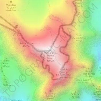
Name: Topografische Karte Mont Blanc - Monte Bianco, Höhe, Relief.
Durchschnittliche Höhe: 4.092 m
Minimale Höhe: 3.347 m
Maximale Höhe: 4.804 m
The climate is cold and temperate (Köppen climate classification Cfb), and is greatly influenced by altitude. Being the highest part of the Alps, Mont Blanc and surrounding mountains can create their own weather patterns. Temperatures drop as the mountains gain in height, and the summit of Mont Blanc is a permanent ice cap, with temperatures around −20 °C (−4 °F). The summit is also prone to strong winds and sudden weather changes. Because of its great overall height, a considerable proportion is permanently glaciated or snow-covered and is exposed to extremely cold conditions.
Andere topografische Karten
Klicken Sie auf eine Karte, um ihre Topografie, ihre Höhe und ihr Relief anzuzeigen.
Aiguille du Tacul
France > Auvergne-Rhône-Alpes > Upper Savoy > Chamonix-Mont-Blanc
Aiguille du Tacul, Chamonix-Mont-Blanc, Bonneville, Upper Savoy, Auvergne-Rhône-Alpes, Metropolitan France, 74400, France
Durchschnittliche Höhe: 2.782 m
Aiguille du Jardin
France > Auvergne-Rhône-Alpes > Upper Savoy > Chamonix-Mont-Blanc
Aiguille du Jardin, Chamonix-Mont-Blanc, Bonneville, Upper Savoy, Auvergne-Rhône-Alpes, Metropolitan France, 74400, France
Durchschnittliche Höhe: 3.254 m
Montenvers
France > Auvergne-Rhône-Alpes > Upper Savoy > Chamonix-Mont-Blanc
Montenvers, Chamonix-Mont-Blanc, Bonneville, Upper Savoy, Auvergne-Rhône-Alpes, Metropolitan France, 74400, France
Durchschnittliche Höhe: 1.801 m
Les Bossons
France > Auvergne-Rhône-Alpes > Upper Savoy > Chamonix-Mont-Blanc
Les Bossons, Chamonix-Mont-Blanc, Bonneville, Upper Savoy, Auvergne-Rhône-Alpes, Metropolitan France, 74400, France
Durchschnittliche Höhe: 1.376 m
Aiguille du Midi
France > Auvergne-Rhône-Alpes > Upper Savoy > Chamonix-Mont-Blanc
Aiguille du Midi, Chamonix-Mont-Blanc, Bonneville, Upper Savoy, Auvergne-Rhône-Alpes, Metropolitan France, 74400, France
Durchschnittliche Höhe: 3.097 m