
Topografische Karte Kanarraville
Interaktive Karte
Klicken Sie auf die Karte, um die Höhe anzuzeigen.
Über diese Karte
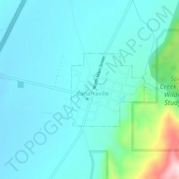
Name: Topografische Karte Kanarraville, Höhe, Relief.
Ort: Kanarraville, Iron County, Utah, 84742, United States (37.53236 -113.18705 37.54340 -113.17311)
Durchschnittliche Höhe: 1.721 m
Minimale Höhe: 1.658 m
Maximale Höhe: 2.058 m
Andere topografische Karten
Klicken Sie auf eine Karte, um ihre Topografie, ihre Höhe und ihr Relief anzuzeigen.
Cedar City
United States > Utah > Iron County
Cedar City, Iron County, Utah, United States
Durchschnittliche Höhe: 1.975 m
Paragonah
United States > Utah > Iron County
Paragonah, Iron County, Utah, 84760, United States
Durchschnittliche Höhe: 1.801 m
The Three Peaks
United States > Utah > Iron County
The Three Peaks, Iron County, Utah, United States
Durchschnittliche Höhe: 1.789 m
Brian Head
United States > Utah > Iron County
Brian Head, Iron County, Utah, 84719, United States
Durchschnittliche Höhe: 3.031 m
Cedar Breaks
United States > Utah > Iron County
Cedar Breaks, Iron County, Utah, United States
Durchschnittliche Höhe: 2.843 m
Newcastle
United States > Utah > Iron County
Newcastle, Iron County, Utah, United States
Durchschnittliche Höhe: 1.640 m
Cedar City
United States > Utah > Iron County > Cedar City > Cedar City
Cedar City, Iron County, Utah, 84720, United States
Durchschnittliche Höhe: 2.087 m
Beryl
United States > Utah > Iron County
Beryl, Iron County, Utah, United States
Durchschnittliche Höhe: 1.573 m
Enoch
United States > Utah > Iron County
Enoch, Iron County, Utah, United States
Durchschnittliche Höhe: 1.769 m
Strawberry Point
United States > Utah > Iron County
Strawberry Point, Iron County, Utah, 84772, United States
Durchschnittliche Höhe: 2.436 m
Parowan
United States > Utah > Iron County
Parowan, Iron County, Utah, 84761, United States
Durchschnittliche Höhe: 2.002 m