
Topografische Karte Eperrais
Interaktive Karte
Klicken Sie auf die Karte, um die Höhe anzuzeigen.
Über diese Karte
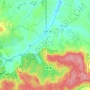
Name: Topografische Karte Eperrais, Höhe, Relief.
Durchschnittliche Höhe: 189 m
Minimale Höhe: 148 m
Maximale Höhe: 255 m
Andere topografische Karten
Klicken Sie auf eine Karte, um ihre Topografie, ihre Höhe und ihr Relief anzuzeigen.
Les Batailles
France > Normandie > Orne > Belforêt-en-Perche
Les Batailles, Le Gué-de-la-Chaîne, Belforêt-en-Perche, Mortagne-au-Perche, Orne, Normandie, France métropolitaine, 61130, France
Durchschnittliche Höhe: 184 m
Bouvigny
France > Normandie > Orne > Belforêt-en-Perche
Bouvigny, La Perrière, Belforêt-en-Perche, Mortagne-au-Perche, Orne, Normandie, France métropolitaine, 61360, France
Durchschnittliche Höhe: 179 m
Beau Repos
France > Normandie > Orne > Belforêt-en-Perche
Beau Repos, Eperrais, Belforêt-en-Perche, Mortagne-au-Perche, Orne, Normandie, France métropolitaine, 61400, France
Durchschnittliche Höhe: 180 m
Sérigny
France > Normandie > Orne > Belforêt-en-Perche
Sérigny, Belforêt-en-Perche, Mortagne-au-Perche, Orne, Normandie, France métropolitaine, 61130, France
Durchschnittliche Höhe: 196 m
La Petite Grange
France > Normandie > Orne > Belforêt-en-Perche
La Petite Grange, La Perrière, Belforêt-en-Perche, Mortagne-au-Perche, Orne, Normandie, France métropolitaine, 61360, France
Durchschnittliche Höhe: 167 m
Le Champu
France > Normandie > Orne > Belforêt-en-Perche
Le Champu, La Perrière, Belforêt-en-Perche, Mortagne-au-Perche, Orne, Normandie, France métropolitaine, 61360, France
Durchschnittliche Höhe: 156 m
La Perrière
France > Normandie > Orne > Belforêt-en-Perche
La Perrière, Belforêt-en-Perche, Mortagne-au-Perche, Orne, Normandie, France métropolitaine, 61360, France
Durchschnittliche Höhe: 174 m