
Topografische Karte Buna Cerca
Interaktive Karte
Klicken Sie auf die Karte, um die Höhe anzuzeigen.
Über diese Karte
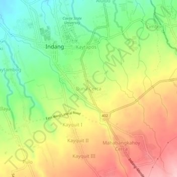
Name: Topografische Karte Buna Cerca, Höhe, Relief.
Ort: Buna Cerca, Indang, Cavite, Calabarzon, 4122, Philippines (14.16631 120.86631 14.20631 120.90631)
Durchschnittliche Höhe: 333 m
Minimale Höhe: 253 m
Maximale Höhe: 418 m
Andere topografische Karten
Klicken Sie auf eine Karte, um ihre Topografie, ihre Höhe und ihr Relief anzuzeigen.
Mahabangkahoy Lejos
Philippines > Cavite > Indang
Mahabangkahoy Lejos, Indang, Cavite, Calabarzon, 4122, Philippines
Durchschnittliche Höhe: 465 m
Indang
Philippines > Cavite > Indang
Indang, Cavite, Calabarzon, 4122, Philippines
Durchschnittliche Höhe: 298 m
Banaba Lejos
Philippines > Cavite > Indang
Banaba Lejos, Indang, Cavite, Calabarzon, 4122, Philippines
Durchschnittliche Höhe: 152 m
Banaba Cerca
Philippines > Cavite > Indang
Banaba Cerca, Indang, Cavite, Calabarzon, 4122, Philippines
Durchschnittliche Höhe: 217 m
Kaytambog
Philippines > Cavite > Indang
Kaytambog, Indang, Cavite, Calabarzon, 4122, Philippines
Durchschnittliche Höhe: 294 m
Mahabangkahoy Cerca
Philippines > Cavite > Indang
Mahabangkahoy Cerca, Indang, Cavite, Calabarzon, 4122, Philippines
Durchschnittliche Höhe: 380 m
Kaytapos
Philippines > Cavite > Indang
Kaytapos, Indang, Cavite, Calabarzon, 4122, Philippines
Durchschnittliche Höhe: 307 m
Limbon
Philippines > Cavite > Indang
Limbon, Indang, Cavite, Calabarzon, 4122, Philippines
Durchschnittliche Höhe: 316 m
Kayquit
Philippines > Cavite > Indang > Kayquit
Kayquit, Indang, Cavite, Calabarzon, 4122, Philippines
Durchschnittliche Höhe: 325 m