Geolokalisieren

Topografische Karte Kannur

Klicken Sie auf die Karte, um die Höhe anzuzeigen.

👉 Easily get elevation data in JSON, GeoTIFF and KML formats using Elevation API
Vielen Dank für die Unterstützung dieser Website ❤️
Spenden

Kannur

Kannur has an elevation of 1.02 metres or 3.3 feet along the coast of the Laccadive Sea, with a sandy coastal area. The city has an 8 kilometres (5.0 miles)-long seashore and a 3 kilometres (1.9 miles)-long beach at Payyambalam. Kannur is located north of Kozhikode, south of Kasargod and Mangalore, west of the Western Ghat regions of Kodagu and Wayanad, and east of the Laccadive Sea. Mappila Bay harbour at Ayikkara. On one side, there is St. Angelo Fort (built in 1505) and on the other side is Arakkal palace. Muzhappilangad Beach, the longest Drive-in Beach in Asia, is located in Kannur. Vayalapra Lake is near Madayi.

Wikipedia (CC-BY-SA 3.0)

👉 Easily get elevation data in JSON, GeoTIFF and KML formats using Elevation API
Vielen Dank für die Unterstützung dieser Website ❤️
Spenden

Rüsten Sie sich für Ihr nächstes Abenteuer:

Als Amazon-Partner verdient diese Website an qualifizierten Käufen, ohne dass Ihnen zusätzliche Kosten entstehen.

Über diese Karte

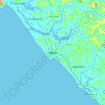
Name: Topografische Karte Kannur, Höhe, Relief.

Ort: Kannur, Kerala, 670004, India (11.71638 75.21380 12.03638 75.53380)

Durchschnittliche Höhe: 13 m

Minimale Höhe: -4 m

Maximale Höhe: 225 m

Andere topografische Karten

Klicken Sie auf eine Karte, um ihre Topografie, ihre Höhe und ihr Relief anzuzeigen.

Pallikunnu

India > Kerala > Kannur

Durchschnittliche Höhe: 14 m

Kannur

India > Kerala > Kannur

Kannur has an elevation of 1.02 metres or 3.3 feet along the coast of the Laccadive Sea, with a sandy coastal area. The city has an 8 kilometres (5.0 mi)-long seashore and a 3 kilometres (1.9 mi)-long beach at Payyambalam. Kannur is located north of Kozhikode, south of Kasargod and Mangalore, west of the…

Durchschnittliche Höhe: 14 m

Chakkarakal

India > Kerala > Kannur > Movancherry > Kavinmoola

Durchschnittliche Höhe: 35 m

Peralassery

India > Kerala > Kannur > Kadachira

Durchschnittliche Höhe: 21 m

Vielen Dank für die Unterstützung dieser Website ❤️
Spenden

Rüsten Sie sich für Ihr nächstes Abenteuer:

Als Amazon-Partner verdient diese Website an qualifizierten Käufen, ohne dass Ihnen zusätzliche Kosten entstehen.

Eachur

India > Kerala > Kannur > Kanachery

Durchschnittliche Höhe: 27 m

Puzhathi

India > Kerala > Kannur

Durchschnittliche Höhe: 19 m

Thana

India > Kerala > Kannur > Kannur

Durchschnittliche Höhe: 20 m

Kannur

India > Kerala > Kannur

Kannur has an elevation of 1.02 metres or 3.3 feet along the coast of the Laccadive Sea, with a sandy coastal area. The city has an 8 kilometres (5.0 mi)-long seashore and a 3 kilometres (1.9 mi)-long beach at Payyambalam. Kannur is located north of Kozhikode, south of Kasargod and Mangalore, west of the…

Durchschnittliche Höhe: 14 m

Vielen Dank für die Unterstützung dieser Website ❤️
Spenden

Rüsten Sie sich für Ihr nächstes Abenteuer:

Als Amazon-Partner verdient diese Website an qualifizierten Käufen, ohne dass Ihnen zusätzliche Kosten entstehen.

Kannur

India > Kerala > Kannur

Kannur has an elevation of 1.02 metres or 3.3 feet along the coast of the Laccadive Sea, with a sandy coastal area. The city has an 8 kilometres (5.0 mi)-long seashore and a 3 kilometres (1.9 mi)-long beach at Payyambalam. Kannur is located north of Kozhikode, south of Kasargod and Mangalore, west of the…

Durchschnittliche Höhe: 14 m

Rüsten Sie sich für Ihr nächstes Abenteuer:

🌦️Regenjacke - Wasserdichte Jacke für schlechtes Wetter
Notfall Biwaksack - Lebenswichtiger Schutz bei ungeplantem Biwak
🧿Insektenabwehr - Repellent für Outdoor
🌦️Gamaschen für Wanderer - Schutz vor Nässe, Schlamm und Schnee in unwegsamem Gelände
🧦Wandersocken - Atmungsaktive Socken für lange Wanderungen

Als Amazon-Partner verdient diese Website an qualifizierten Käufen, ohne dass Ihnen zusätzliche Kosten entstehen.