Geolokalisieren

Topografische Karte Lewisville

Interaktive Karte

Klicken Sie auf die Karte, um die Höhe anzuzeigen.

Über diese Karte

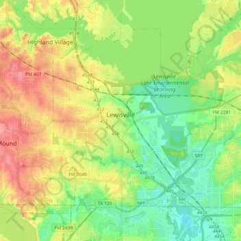
Name: Topografische Karte Lewisville, Höhe, Relief.

Ort: Lewisville, Denton County, Texas, United States (32.98512 -97.04566 33.10035 -96.86587)

Durchschnittliche Höhe: 160 m

Minimale Höhe: 129 m

Maximale Höhe: 202 m

Lewisville is at 33°2′18″N 97°0′22″W / 33.03833°N 97.00611°W / 33.03833; -97.00611 (33.038316, −97.006232) at an elevation of about 550 feet (170 m). It has a total area of 42.5 square miles (110 km2), of which 6.1 sq mi (16 km2) is covered by water. It lies at the southern end of Denton County and the northern end of the Dallas–Fort Worth metroplex, in the eastern part of the Cross Timbers region of Texas between the Texas Blackland Prairies and the Grand Prairie. Vista Ridge, a small plateau, is in the southeast corner of Lewisville, and the lowest part of Denton County, at 484 feet (148 m), is found in the city. Lewisville sits above the Barnett Shale, a geological formation containing a large quantity of natural shale gas.

Wikipedia (CC-BY-SA 3.0)

Andere topografische Karten

Klicken Sie auf eine Karte, um ihre Topografie, ihre Höhe und ihr Relief anzuzeigen.

Stony

United States > Texas > Denton County

Stony, Denton County, Texas, United States

Durchschnittliche Höhe: 240 m

Fort Worth

United States > Texas > Denton County

Fort Worth, Denton County, Texas, United States

Durchschnittliche Höhe: 213 m

Cross Roads

United States > Texas > Denton County

Cross Roads, Denton County, Texas, United States

Durchschnittliche Höhe: 172 m

Argyle

United States > Texas > Denton County

Argyle, Denton County, Texas, United States

Durchschnittliche Höhe: 206 m

Grapevine Lake

United States > Texas > Denton County > Grapevine > Flower Mound

Grapevine Lake, Flower Mound, Grapevine, Denton County, Texas, United States

Durchschnittliche Höhe: 181 m

Corinth

United States > Texas > Denton County

Corinth, Denton County, Texas, 76210, United States

Durchschnittliche Höhe: 180 m

Flower Mound

United States > Texas > Denton County

Flower Mound, Denton County, Texas, United States

Durchschnittliche Höhe: 178 m

Jagoe

United States > Texas > Denton County > Denton

Jagoe, Denton, Denton County, Texas, 76226, United States

Durchschnittliche Höhe: 189 m

Denton

United States > Texas > Denton County > Denton

Denton, Denton County, Texas, United States

Durchschnittliche Höhe: 195 m

Sequoia Park

United States > Texas > Denton County > Denton

Sequoia Park, Denton, Denton County, Texas, 76201, United States

Durchschnittliche Höhe: 198 m

Hickory Creek

United States > Texas > Denton County > Hickory Creek

Hickory Creek, Denton County, Texas, United States

Durchschnittliche Höhe: 169 m

Sanger

United States > Texas > Denton County

Sanger, Denton County, Texas, 76266, United States

Durchschnittliche Höhe: 209 m

Lakewood Village

United States > Texas > Denton County > Lakewood Village > Lakewood Village

Lakewood Village, Denton County, Texas, 75068, United States

Durchschnittliche Höhe: 163 m

Little Elm

United States > Texas > Denton County

Little Elm, Denton County, Texas, United States

Durchschnittliche Höhe: 171 m

Justin

United States > Texas > Denton County

Justin, Denton County, Texas, United States

Durchschnittliche Höhe: 198 m

New Hope

United States > Texas > Denton County > Cross Roads > New Hope

New Hope, Cross Roads, Denton County, Texas, 76227, United States

Durchschnittliche Höhe: 185 m

Lewisville

United States > Texas > Denton County > Lewisville

Lewisville, Denton County, Texas, 75067, United States

Durchschnittliche Höhe: 174 m

Westlake

United States > Texas > Denton County

Westlake, Denton County, Texas, United States

Durchschnittliche Höhe: 199 m

The Colony

United States > Texas > Denton County

The Colony, Denton County, Texas, 75056, United States

Durchschnittliche Höhe: 175 m