
Topografische Karte Wellston
Interaktive Karte
Klicken Sie auf die Karte, um die Höhe anzuzeigen.
Über diese Karte
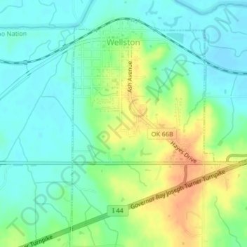
Name: Topografische Karte Wellston, Höhe, Relief.
Ort: Wellston, Lincoln County, Oklahoma, 74881, United States (35.67377 -97.07035 35.69683 -97.04039)
Durchschnittliche Höhe: 273 m
Minimale Höhe: 258 m
Maximale Höhe: 299 m
Andere topografische Karten
Klicken Sie auf eine Karte, um ihre Topografie, ihre Höhe und ihr Relief anzuzeigen.
Prague
United States > Oklahoma > Lincoln County
Prague, Lincoln County, Oklahoma, United States
Durchschnittliche Höhe: 304 m
Stroud
United States > Oklahoma > Lincoln County
Stroud, Lincoln County, Oklahoma, 74079, United States
Durchschnittliche Höhe: 272 m
Agra
United States > Oklahoma > Lincoln County
Agra, Lincoln County, Oklahoma, United States
Durchschnittliche Höhe: 309 m
Chandler
United States > Oklahoma > Lincoln County
Chandler, Lincoln County, Oklahoma, 74834, United States
Durchschnittliche Höhe: 280 m
Chandler
United States > Oklahoma > Lincoln County > Chandler > Chandler
Chandler, Lincoln County, Oklahoma, 74834, United States
Durchschnittliche Höhe: 279 m
Meeker
United States > Oklahoma > Lincoln County > Meeker
Meeker, Lincoln County, Oklahoma, United States
Durchschnittliche Höhe: 292 m
Sparks
United States > Oklahoma > Lincoln County
Sparks, Lincoln County, Oklahoma, 74869, United States
Durchschnittliche Höhe: 256 m
Chandler Lake
United States > Oklahoma > Lincoln County > Chandler
Chandler Lake, Chandler, Lincoln County, Oklahoma, United States
Durchschnittliche Höhe: 283 m