
Topografische Karte Mexico City
Interaktive Karte
Klicken Sie auf die Karte, um die Höhe anzuzeigen.
Über diese Karte
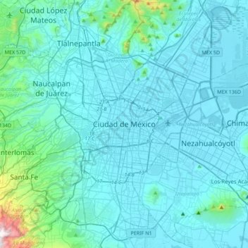
Name: Topografische Karte Mexico City, Höhe, Relief.
Ort: Mexico City, 06060, Mexico (19.27263 -99.29318 19.59263 -98.97318)
Durchschnittliche Höhe: 2.321 m
Minimale Höhe: 2.223 m
Maximale Höhe: 3.510 m
Mexico is crossed from north to south by two mountain ranges known as Sierra Madre Oriental and Sierra Madre Occidental, which are the extension of the Rocky Mountains from northern North America. From east to west at the center, the country is crossed by the Trans-Mexican Volcanic Belt also known as the Sierra Nevada. A fourth mountain range, the Sierra Madre del Sur, runs from Michoacán to Oaxaca. As such, the majority of the Mexican central and northern territories are located at high altitudes, and the highest elevations are found at the Trans-Mexican Volcanic Belt: Pico de Orizaba (5,700 m or 18,701 ft), Popocatépetl (5,462 m or 17,920 ft) and Iztaccihuatl (5,286 m or 17,343 ft) and the Nevado de Toluca (4,577 m or 15,016 ft). Three major urban agglomerations are located in the valleys between these four elevations: Toluca, Greater Mexico City and Puebla. An important geologic feature of the Yucatán peninsula is the Chicxulub crater. The scientific consensus is that the Chicxulub impactor was responsible for the Cretaceous–Paleogene extinction event. Mexico is subject to a number of natural hazards, including hurricanes on both coasts, tsunamis on the Pacific coast, and volcanism.
Andere topografische Karten
Klicken Sie auf eine Karte, um ihre Topografie, ihre Höhe und ihr Relief anzuzeigen.
San Felipe Zapotitlán
Mexico > Oaxaca > Villa Sola de Vega
San Felipe Zapotitlán, Villa Sola de Vega, Oaxaca, Mexico
Durchschnittliche Höhe: 1.763 m
Amatenango del Valle
Mexico > Chiapas > Amatenango del Valle
Amatenango del Valle, Chiapas, Mexico
Durchschnittliche Höhe: 1.976 m
Colotitlán
Mexico > Jalisco > Tenamaxtlán
Colotitlán, Tenamaxtlán, Región Sierra de Amula, Jalisco, 48592, Mexico
Durchschnittliche Höhe: 1.412 m
Cabo San Lucas
Mexico > Baja California Sur > Los Cabos Municipality
Cabo San Lucas, Los Cabos Municipality, Baja California Sur, 23470, Mexico
Durchschnittliche Höhe: 94 m
Bosques de las Lomas
Mexico > State of Mexico > Ciudad Satélite
Bosques de las Lomas, Miguel Hidalgo, Ciudad Satélite, Mexico City, State of Mexico, 11910, Mexico
Durchschnittliche Höhe: 2.414 m
Lázaro Cárdenas
Mexico > State of Mexico > Naucalpan de Juárez
Lázaro Cárdenas, Naucalpan de Juárez, State of Mexico, 53569, Mexico
Durchschnittliche Höhe: 2.282 m
San Miguel de Allende
Mexico > Guanajuato > San Miguel de Allende
San Miguel de Allende, Guanajuato, Mexico
Durchschnittliche Höhe: 1.964 m
Cancún
Mexico > Quintana Roo > Benito Juárez
Cancún, Benito Juárez, Quintana Roo, Mexico
Durchschnittliche Höhe: 5 m
Tlajomulco de Zúñiga
Tlajomulco de Zúñiga, Región Centro, Jalisco, Mexico
Durchschnittliche Höhe: 1.670 m
Querétaro
Mexico > Querétaro > Municipio de Querétaro
Querétaro, Municipio de Querétaro, Querétaro, Mexico
Durchschnittliche Höhe: 1.921 m
San Antonio la Isla
San Antonio la Isla, State of Mexico, Mexico
Durchschnittliche Höhe: 2.585 m
San Cristóbal
Mexico > Chiapas > San Cristóbal de las Casas
San Cristóbal, San Cristóbal de las Casas, Chiapas, 29200, Mexico
Durchschnittliche Höhe: 2.038 m
Cedros Island
Mexico > Baja California > Municipio de Ensenada
Cedros Island, Municipio de Ensenada, Baja California, 22990, Mexico
Durchschnittliche Höhe: 67 m
Interlomas
Interlomas, Huixquilucan, 52760, Mexico
Durchschnittliche Höhe: 2.656 m
Yucatán Peninsula
Mexico > Quintana Roo > Othón P. Blanco
Yucatán Peninsula, Othón P. Blanco, Quintana Roo, Mexico
Durchschnittliche Höhe: 100 m
Tepeji del Río de Ocampo
Tepeji del Río de Ocampo, Hidalgo, Mexico
Durchschnittliche Höhe: 2.296 m
Malinche
Mexico > Tlaxcala > Teolocholco
Malinche, Teolocholco, Tlaxcala, Mexico
Durchschnittliche Höhe: 3.911 m
San Juan Colorado
Mexico > Oaxaca > San Juan Colorado
San Juan Colorado, Oaxaca, 71750, Mexico
Durchschnittliche Höhe: 412 m
San Miguel
Mexico > Nuevo León > García
San Miguel, García, Nuevo León, Mexico
Durchschnittliche Höhe: 1.431 m
Jesús del Monte
Jesús del Monte, Morelia, Michoacán, 58350, Mexico
Durchschnittliche Höhe: 2.136 m
Guadalajara
Mexico > Jalisco > Guadalajara
Guadalajara, Jalisco, 44360, Mexico
Durchschnittliche Höhe: 1.572 m
Casas Grandes
Mexico > Chihuahua > Casas Grandes
Casas Grandes, Chihuahua, 31850, Mexico
Durchschnittliche Höhe: 1.503 m
Sierra Negra
Mexico > Puebla > Chalchicomula de Sesma
Sierra Negra, Chalchicomula de Sesma, Puebla, Mexico
Durchschnittliche Höhe: 4.099 m
Llano Hermoso
Mexico > Durango > Nuevo Ideal
Llano Hermoso, Nuevo Ideal, Durango, Mexico
Durchschnittliche Höhe: 1.967 m
Isla Cozumel
Mexico > Quintana Roo > Cozumel
Isla Cozumel, Cozumel, Quintana Roo, Mexico
Durchschnittliche Höhe: 2 m
Río Blanco
Río Blanco, Zapopan, Región Centro, Jalisco, 45158, Mexico
Durchschnittliche Höhe: 1.575 m
Puerto Vallarta
Mexico > Jalisco > Puerto Vallarta
Puerto Vallarta, Región Costa Norte, Jalisco, 48300, Mexico
Durchschnittliche Höhe: 306 m
Ventanilla
Mexico > Oaxaca > Santa María Colotepec
Ventanilla, Santa María Colotepec, Oaxaca, 70937, Mexico
Durchschnittliche Höhe: 79 m
Santa María Colotepec
Santa María Colotepec, Oaxaca, Mexico
Durchschnittliche Höhe: 179 m