
Spenden
Rüsten Sie sich für Ihr nächstes Abenteuer:
Als Amazon-Partner verdient diese Website an qualifizierten Käufen, ohne dass Ihnen zusätzliche Kosten entstehen.
Topografische Karte Payson
Klicken Sie auf die Karte, um die Höhe anzuzeigen.
Spenden
Rüsten Sie sich für Ihr nächstes Abenteuer:
Als Amazon-Partner verdient diese Website an qualifizierten Käufen, ohne dass Ihnen zusätzliche Kosten entstehen.
Payson
Located in northern Gila County at an elevation of 5,000 feet (1,500 m), the town has a total area of 19.5 square miles (51 km2). The Mogollon Rim, the southern boundary of the Colorado Plateau, lies to the north of Payson, with elevations exceeding 7,500 feet (2,300 m); there are many cold water lakes on top of the rim. They are stocked with fish by the Arizona Game and Fish Department.
Spenden
Rüsten Sie sich für Ihr nächstes Abenteuer:
Als Amazon-Partner verdient diese Website an qualifizierten Käufen, ohne dass Ihnen zusätzliche Kosten entstehen.
Über diese Karte
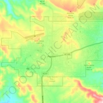
Name: Topografische Karte Payson, Höhe, Relief.
Ort: Payson, Gila County, Arizona, 85072, United States (34.21706 -111.37054 34.27176 -111.27319)
Durchschnittliche Höhe: 1.522 m
Minimale Höhe: 1.379 m
Maximale Höhe: 1.725 m
Spenden
Rüsten Sie sich für Ihr nächstes Abenteuer:
Als Amazon-Partner verdient diese Website an qualifizierten Käufen, ohne dass Ihnen zusätzliche Kosten entstehen.
Andere topografische Karten
Klicken Sie auf eine Karte, um ihre Topografie, ihre Höhe und ihr Relief anzuzeigen.
Spenden
Rüsten Sie sich für Ihr nächstes Abenteuer:
Als Amazon-Partner verdient diese Website an qualifizierten Käufen, ohne dass Ihnen zusätzliche Kosten entstehen.
Spenden
Rüsten Sie sich für Ihr nächstes Abenteuer:
Als Amazon-Partner verdient diese Website an qualifizierten Käufen, ohne dass Ihnen zusätzliche Kosten entstehen.
Star Valley
United States > Arizona > Gila County > Star Valley
According to the United States Census Bureau, the town has a total area of 36.1 square miles (93.6 km2), of which 0.01 square miles (0.02 km2), or 0.03%, is water. Star Valley sits at an elevation of 4,650 feet (1,420 m) and takes its name from the valley in which it is located, formed by Houston Creek, which…
Durchschnittliche Höhe: 1.521 m
Spenden
Rüsten Sie sich für Ihr nächstes Abenteuer:
Als Amazon-Partner verdient diese Website an qualifizierten Käufen, ohne dass Ihnen zusätzliche Kosten entstehen.