
Topografische Karte Montpelier
Interaktive Karte
Klicken Sie auf die Karte, um die Höhe anzuzeigen.
Über diese Karte
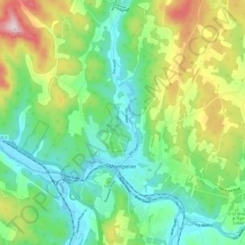
Name: Topografische Karte Montpelier, Höhe, Relief.
Ort: Montpelier, Washington County, Vermont, 05602, United States (44.23492 -72.61245 44.31331 -72.52509)
Durchschnittliche Höhe: 284 m
Minimale Höhe: 152 m
Maximale Höhe: 564 m
Montpelier is located in the north-central area of Vermont. The city center is a flat clay zone (elevation 520 ft/158 m), surrounded by hills and granite ledges. Towne Hill runs in a 2-mile (3.2 km) ridge (~900 ft/275 m) along the northern edge of the city.
Andere topografische Karten
Klicken Sie auf eine Karte, um ihre Topografie, ihre Höhe und ihr Relief anzuzeigen.
Worcester
United States > Vermont > Washington County
Worcester, Washington County, Vermont, 05682, United States
Durchschnittliche Höhe: 461 m
Duxbury
United States > Vermont > Washington County
Duxbury, Washington County, Vermont, 05676, United States
Durchschnittliche Höhe: 335 m
Middlesex
United States > Vermont > Washington County
Middlesex, Washington County, Vermont, United States
Durchschnittliche Höhe: 331 m
Woodbury
United States > Vermont > Washington County
Woodbury, Washington County, Vermont, 05681, United States
Durchschnittliche Höhe: 411 m
Adamant
United States > Vermont > Washington County > Calais
Adamant, Calais, Washington County, Vermont, 05640, United States
Durchschnittliche Höhe: 365 m
East Montpelier
United States > Vermont > Washington County
East Montpelier, Washington County, Vermont, United States
Durchschnittliche Höhe: 311 m
Marshfield
United States > Vermont > Washington County
Marshfield, Washington County, Vermont, 05658, United States
Durchschnittliche Höhe: 403 m
Cabot
United States > Vermont > Washington County
Cabot, Washington County, Vermont, 05647, United States
Durchschnittliche Höhe: 458 m
Roxbury
United States > Vermont > Washington County
Roxbury, Washington County, Vermont, 05669, United States
Durchschnittliche Höhe: 494 m
Mount Ellen
United States > Vermont > Washington County > Warren
Mount Ellen, Warren, Washington County, Vermont, United States
Durchschnittliche Höhe: 906 m
Sugarbush Village
United States > Vermont > Washington County > Warren
Sugarbush Village, Warren, Washington County, Vermont, United States
Durchschnittliche Höhe: 606 m
Waterbury
United States > Vermont > Washington County > Waterbury
Waterbury, Washington County, Vermont, United States
Durchschnittliche Höhe: 199 m
Barre City
United States > Vermont > Washington County
Barre City, Washington County, Vermont, 05641, United States
Durchschnittliche Höhe: 261 m
East Roxbury
United States > Vermont > Washington County > Roxbury
East Roxbury, Roxbury, Washington County, Vermont, United States
Durchschnittliche Höhe: 470 m
North Montpelier
United States > Vermont > Washington County > East Montpelier
North Montpelier, East Montpelier, Washington County, Vermont, 05666, United States
Durchschnittliche Höhe: 278 m
Berlin
United States > Vermont > Washington County
Berlin, Washington County, Vermont, United States
Durchschnittliche Höhe: 315 m
North Duxbury
United States > Vermont > Washington County > Duxbury
North Duxbury, Duxbury, Washington County, Vermont, United States
Durchschnittliche Höhe: 275 m
Moretown
United States > Vermont > Washington County > Moretown
Moretown, Washington County, Vermont, 05660, United States
Durchschnittliche Höhe: 383 m
Waitsfield
United States > Vermont > Washington County > Waitsfield
Waitsfield, Washington County, Vermont, 05673, United States
Durchschnittliche Höhe: 424 m
Plainfield
United States > Vermont > Washington County
Plainfield, Washington County, Vermont, 05667, United States
Durchschnittliche Höhe: 386 m
Northfield
United States > Vermont > Washington County > Northfield
Northfield, Washington County, Vermont, 05663, United States
Durchschnittliche Höhe: 298 m
Warren
United States > Vermont > Washington County
Warren, Washington County, Vermont, 05674, United States
Durchschnittliche Höhe: 575 m