
Spenden
Rüsten Sie sich für Ihr nächstes Abenteuer:
Als Amazon-Partner verdient diese Website an qualifizierten Käufen, ohne dass Ihnen zusätzliche Kosten entstehen.
Topografische Karte Nirmal
Klicken Sie auf die Karte, um die Höhe anzuzeigen.
Spenden
Rüsten Sie sich für Ihr nächstes Abenteuer:
Als Amazon-Partner verdient diese Website an qualifizierten Käufen, ohne dass Ihnen zusätzliche Kosten entstehen.
Nirmal
Nirmal is located at 19°06′N 78°21′E / 19.10°N 78.35°E / 19.10; 78.35. It has an average elevation of 340 metres (1100 feet) on the foot hills of Nirmal range, which is located in the Deccan plateau.Nirmal has chain tanks built around it.
Spenden
Rüsten Sie sich für Ihr nächstes Abenteuer:
Als Amazon-Partner verdient diese Website an qualifizierten Käufen, ohne dass Ihnen zusätzliche Kosten entstehen.
Über diese Karte
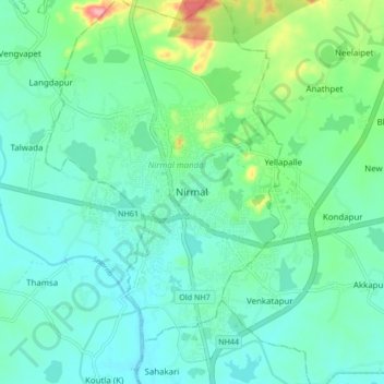
Name: Topografische Karte Nirmal, Höhe, Relief.
Ort: Nirmal, Nirmal mandal, Nirmal, Telangana, 504106, India (19.05246 78.30860 19.13246 78.38860)
Durchschnittliche Höhe: 335 m
Minimale Höhe: 310 m
Maximale Höhe: 424 m
Spenden
Rüsten Sie sich für Ihr nächstes Abenteuer:
Als Amazon-Partner verdient diese Website an qualifizierten Käufen, ohne dass Ihnen zusätzliche Kosten entstehen.