Geolokalisieren

Topografische Karte Madhya Pradesh

Klicken Sie auf die Karte, um die Höhe anzuzeigen.

👉 Easily get elevation data in JSON, GeoTIFF and KML formats using Elevation API
Vielen Dank für die Unterstützung dieser Website ❤️
Spenden

Rüsten Sie sich für Ihr nächstes Abenteuer:

Als Amazon-Partner verdient diese Website an qualifizierten Käufen, ohne dass Ihnen zusätzliche Kosten entstehen.

Madhya Pradesh

Madhya Pradesh literally means "Central Province", and is located in the geographic heart of India in between the latitude of 21.6°N–26.30°N and longitude of 74°9'E–82°48'E. The state straddles the Narmada River, which runs east and west between the Vindhya and Satpura ranges; these ranges and the Narmada are the traditional boundaries between the north and south of India. The highest point in Madhya Pradesh is Dhupgarh, with an elevation of 1,350 m (4,429 ft).

Wikipedia (CC-BY-SA 3.0)

👉 Easily get elevation data in JSON, GeoTIFF and KML formats using Elevation API
Vielen Dank für die Unterstützung dieser Website ❤️
Spenden

Rüsten Sie sich für Ihr nächstes Abenteuer:

Als Amazon-Partner verdient diese Website an qualifizierten Käufen, ohne dass Ihnen zusätzliche Kosten entstehen.

Über diese Karte

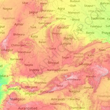
Name: Topografische Karte Madhya Pradesh, Höhe, Relief.

Ort: Madhya Pradesh, India (21.07069 74.02938 26.86956 82.81261)

Durchschnittliche Höhe: 347 m

Minimale Höhe: 16 m

Maximale Höhe: 1.313 m

👉 Easily get elevation data in JSON, GeoTIFF and KML formats using Elevation API
Vielen Dank für die Unterstützung dieser Website ❤️
Spenden

Andere topografische Karten

Klicken Sie auf eine Karte, um ihre Topografie, ihre Höhe und ihr Relief anzuzeigen.

Pune

India > Maharashtra > Pune City Subdistrict

Durchschnittliche Höhe: 641 m

Moongilpatti

India > Tamil Nadu > Mohanur

Durchschnittliche Höhe: 157 m

Puga

India > Ladakh

Durchschnittliche Höhe: 4.616 m

Maharashtra

India > Maharashtra

Maharashtra is the third largest state by area in India. The Western Ghats better known as Sahyadri, are a hilly range running parallel to the coast, at an average elevation of 1,200 metres (4,000 ft). Kalsubai, a peak in the Sahyadris, near Nashik city is the highest elevated point in Maharashtra. To the west…

Durchschnittliche Höhe: 478 m

Bhopal

India > Madhya Pradesh > Huzur Tahsil

Bhopal has an average elevation of 500 metres (1401 ft) and is located in the central part of India, just north of the upper limit of the Vindhya mountain ranges. Located on the Malwa plateau, it is higher than the north Indian plains and the land rises towards the Vindhya Range to the south. The city has…

Durchschnittliche Höhe: 498 m

Mysuru

India > Karnataka > Mysuru taluk

Mysore (/maɪˈsɔːr/ (listen)), officially Mysuru ([ˈmaɪˈsuːɾu] (listen)), is a city in the southern part of the state of Karnataka, India. Mysore city is geographically located between 12° 18′ 26″ north latitude and 76° 38′ 59″ east longitude. It is located at an altitude of 770 m (2,530 ft)…

Durchschnittliche Höhe: 727 m

Vetal Tekdi

India > Maharashtra > Pune City

Durchschnittliche Höhe: 622 m

Udhagamandalam

India > Tamil Nadu > Udhagamandalam

Ooty is situated in the Nilgiri Biosphere Reserve. Many of the forested areas and water bodies are off-limits to most visitors in order to protect this fragile ecosystem. Some areas of the Biosphere Reserve have been earmarked for tourism development, and steps are being undertaken to open these areas to…

Durchschnittliche Höhe: 2.234 m

Vielen Dank für die Unterstützung dieser Website ❤️
Spenden

Rüsten Sie sich für Ihr nächstes Abenteuer:

Als Amazon-Partner verdient diese Website an qualifizierten Käufen, ohne dass Ihnen zusätzliche Kosten entstehen.

Lucknow

India > Uttar Pradesh > Lucknow

The city stands at an elevation of approximately 123 metres (404 ft) above sea level. Lucknow city had an area of 402 km2 (155 square miles) till December 2019, when 88 villages were added to the municipal limits and the area increased to 631 km2 (244 square miles). Bounded on the east by Barabanki, on the…

Durchschnittliche Höhe: 120 m

Gokak

India > Karnataka > Gokak taluku

Gokak is second biggest city after Belgaum city in Belgaum district and is surrounded by the Western Ghats. The Ghataprabha River, which has water almost throughout the year, is the chief source of agricultural and drinking water for local people living in the surrounding villages. It has an average elevation…

Durchschnittliche Höhe: 593 m

3d

India > Rajasthan > Ganganagar Tehsil > 1 LNP

Durchschnittliche Höhe: 178 m

Lamgara

India > Uttarakhand > Lamgara Tehsil

Durchschnittliche Höhe: 1.770 m

Dwarka

India > Gujarat > Okhamandal Taluka

Considered a holy city, Dwarka is well known for its temples and as a pilgrimage centre for Hindus. The Dwarakadhisa Temple, also called Jagat Mandir, located in the heart of Dwarka, is a Vaishnava temple. It was built by Raja Jagat Singh Rathore, hence it is called Jagat Mandir. The temple, facing west, is at…

Durchschnittliche Höhe: 3 m

Jibhi

India > Himachal Pradesh > Banjar

Durchschnittliche Höhe: 2.242 m

Gujarat

India

Durchschnittliche Höhe: 124 m

Chaliyar River

India > Kerala

Durchschnittliche Höhe: 60 m

Vielen Dank für die Unterstützung dieser Website ❤️
Spenden

Rüsten Sie sich für Ihr nächstes Abenteuer:

Als Amazon-Partner verdient diese Website an qualifizierten Käufen, ohne dass Ihnen zusätzliche Kosten entstehen.

Indore

India > Madhya Pradesh > Juni Indore Tahsil

Indore /ɪnˈdɔːr/ (listen) is the most populous and the largest city in the Indian state of Madhya Pradesh. It serves as the headquarters of both Indore District and Indore Division. It is also considered as an education hub of the state and has campuses of both the Indian Institute of Technology and the…

Durchschnittliche Höhe: 555 m

Lucknow

India > Uttar Pradesh > Lucknow

Lucknow stands at an elevation of approximately 123 metres (404 ft) above sea level. The city had an area of 402 km2 (155 square miles) until December 2019, when 88 villages were added to the municipal limits and the area increased to 631 km2 (244 square miles). Bounded on the east by Barabanki, on the west by…

Durchschnittliche Höhe: 120 m

Salem

India > Tamil Nadu

Salem is located at 11°40′N 78°08′E / 11.67°N 78.14°E / 11.67; 78.14, at an average elevation of 278 m (912 ft). The city is surrounded by hills: Nagaramalai on the north, Jarugumalai on the south, Kanjamalai on the west, Godumalai on the east and the Shevaroy Hills on the northeast.…

Durchschnittliche Höhe: 418 m

Kalhorkar

India > Himachal Pradesh > Palampur

Durchschnittliche Höhe: 1.177 m

Vielen Dank für die Unterstützung dieser Website ❤️
Spenden

Rüsten Sie sich für Ihr nächstes Abenteuer:

Als Amazon-Partner verdient diese Website an qualifizierten Käufen, ohne dass Ihnen zusätzliche Kosten entstehen.

Om Parvat

India

Om Parvat is a mountain located in Pithoragarh district of the Uttarakhand, India. Om Parvat's peak elevation is 5,590 m (18,340 ft) above sea level.

Durchschnittliche Höhe: 5.207 m

Spangmik

India

Durchschnittliche Höhe: 4.405 m

Dzo Jongo West

India

Durchschnittliche Höhe: 5.855 m

Thukje

India

Durchschnittliche Höhe: 4.641 m

Vielen Dank für die Unterstützung dieser Website ❤️
Spenden

Rüsten Sie sich für Ihr nächstes Abenteuer:

Als Amazon-Partner verdient diese Website an qualifizierten Käufen, ohne dass Ihnen zusätzliche Kosten entstehen.

Turtuk

India

Durchschnittliche Höhe: 3.284 m

Muntho Dhalo

India

Durchschnittliche Höhe: 4.847 m

Yaldor

India

Durchschnittliche Höhe: 3.795 m

Lungser Kangri

India

Durchschnittliche Höhe: 6.269 m

Vielen Dank für die Unterstützung dieser Website ❤️
Spenden

Rüsten Sie sich für Ihr nächstes Abenteuer:

Als Amazon-Partner verdient diese Website an qualifizierten Käufen, ohne dass Ihnen zusätzliche Kosten entstehen.

Chushul

India

Durchschnittliche Höhe: 4.391 m

South Rimo Glacier

India

Durchschnittliche Höhe: 5.588 m

Underi

India

Durchschnittliche Höhe: 0 m

Kiari

India

Durchschnittliche Höhe: 4.267 m

Vielen Dank für die Unterstützung dieser Website ❤️
Spenden

South Pullu

India

Durchschnittliche Höhe: 4.859 m

Chalisgaon

India > Maharashtra > Chalisgaon

Chalisgaon is located at 20°28′N 75°01′E / 20.47°N 75.02°E / 20.47; 75.02. It has an average elevation of 344 metres (1128 feet).

Durchschnittliche Höhe: 345 m

Hanle

India

Durchschnittliche Höhe: 4.287 m

Rajnandgaon

India > Chhattisgarh

Durchschnittliche Höhe: 353 m

Vielen Dank für die Unterstützung dieser Website ❤️
Spenden

Rüsten Sie sich für Ihr nächstes Abenteuer:

Als Amazon-Partner verdient diese Website an qualifizierten Käufen, ohne dass Ihnen zusätzliche Kosten entstehen.

Chaliyam

India > Kerala > Kozhikode

Durchschnittliche Höhe: 5 m

Hemis

India

Durchschnittliche Höhe: 5.218 m

Karzok

India

Durchschnittliche Höhe: 4.618 m

Bhubaneshwar

India > Odisha > Bhubaneswar (M.Corp.)

Bhubaneswar is in Khordha district of Odisha. It is in the eastern coastal plains, along the axis of the Eastern Ghats mountains. The city has an average altitude of 45 m (148 ft) above sea level. It lies southwest of the Mahanadi River that forms the northern boundary of Bhubaneswar metropolitan area, within…

Durchschnittliche Höhe: 30 m

Vielen Dank für die Unterstützung dieser Website ❤️
Spenden

Rüsten Sie sich für Ihr nächstes Abenteuer:

Als Amazon-Partner verdient diese Website an qualifizierten Käufen, ohne dass Ihnen zusätzliche Kosten entstehen.

Mahim Bay

India > Maharashtra > Mumbai

Durchschnittliche Höhe: 3 m

The Nilgiris

India > Tamil Nadu

Durchschnittliche Höhe: 639 m

Thiruvananthapuram

India > Kerala > Thiruvananthapuram

Thiruvananthapuram is built on seven hills by the seashore and is at 8°30′N 76°54′E / 8.5°N 76.9°E / 8.5; 76.9 on the west coast, near the southern tip of mainland India. The city is on the west coast of India and is bounded by the Laccadive Sea to its west and the Western Ghats to its east.…

Durchschnittliche Höhe: 33 m

Piram Bet

India

Durchschnittliche Höhe: 14 m

Vielen Dank für die Unterstützung dieser Website ❤️
Spenden

Rüsten Sie sich für Ihr nächstes Abenteuer:

Als Amazon-Partner verdient diese Website an qualifizierten Käufen, ohne dass Ihnen zusätzliche Kosten entstehen.

Gorakhpur

India > Uttar Pradesh

Durchschnittliche Höhe: 90 m

Jalgaon

India > Maharashtra

Durchschnittliche Höhe: 360 m

Bhasmehr

India > Himachal Pradesh > Palampur

Durchschnittliche Höhe: 1.312 m

Lonand

India > Maharashtra > Khandala

Lonand is located at 18°02′25″N 74°11′14″E / 18.0404°N 74.1872°E / 18.0404; 74.1872. It has an average elevation of 597 metres (1961 feet). It is situated on the banks of Khemavati river at the border of Pune district and Satara district.

Durchschnittliche Höhe: 599 m

Vielen Dank für die Unterstützung dieser Website ❤️
Spenden

Rüsten Sie sich für Ihr nächstes Abenteuer:

Als Amazon-Partner verdient diese Website an qualifizierten Käufen, ohne dass Ihnen zusätzliche Kosten entstehen.

Madhuban Dam

India > Gujarat > Kaparada Taluka

Durchschnittliche Höhe: 67 m

Poopara

India > Kerala > Udumbanchola

Durchschnittliche Höhe: 1.140 m

Kunigal

India > Karnataka > Kunigal taluk

Kunigal is located at 13°01′N 77°02′E / 13.02°N 77.03°E / 13.02; 77.03. It has an average elevation of 773 metres (2536 feet). It is situated on the National Highway 75 (India) connecting Bengaluru and Mangaluru and State Highway 33 (Karnataka) connecting Tumakuru and Madduru. Kunigal is…

Durchschnittliche Höhe: 775 m

Solan

India > Himachal Pradesh > Solan

Solan is a city in the Indian state of Himachal Pradesh and the district headquarters of Solan district. It is located 45.5 kilometres (28 mi) south of the state capital, Shimla. Solan has an average elevation of 1,550 metres (5,090 ft). The city is situated between Chandigarh (joint capital of Punjab and…

Durchschnittliche Höhe: 1.312 m

Meghpar (Kumbhardi)

India > Gujarat > Anjar Taluka

Durchschnittliche Höhe: 39 m

Naduveerapattu

India > Tamil Nadu

Durchschnittliche Höhe: 22 m

Porbandar

India > Gujarat > Porbandar Taluka

Porbandar is located at 21°37′48″N 69°36′0″E / 21.63000°N 69.60000°E / 21.63000; 69.60000. It has an average elevation of 1 metre (3 ft).

Durchschnittliche Höhe: 18 m

Vielen Dank für die Unterstützung dieser Website ❤️
Spenden

Rüsten Sie sich für Ihr nächstes Abenteuer:

Als Amazon-Partner verdient diese Website an qualifizierten Käufen, ohne dass Ihnen zusätzliche Kosten entstehen.

Kizhakkencherry

India > Kerala > Alathur

Durchschnittliche Höhe: 66 m

Alandi

India > Maharashtra > Nashik Taluka > Gangapur

Durchschnittliche Höhe: 631 m

Jalna

India > Uttarakhand > Lamgara Tehsil

Durchschnittliche Höhe: 1.783 m

Kashmir Valley

India > Jammu and Kashmir > Srīnagar > Shalteng

The Kashmir Valley lies between latitude 33° and 35°N, and longitude 73° and 76°E. The valley is 100 km (62 mi) wide and covers 15,520.3 km2 (5,992.4 sq mi) in area. It is bounded by sub-ranges of the Western Himalayas: the Great Himalayas bound it in the northeast and separate it from the Tibetan Plateau,…

Durchschnittliche Höhe: 1.585 m

Vielen Dank für die Unterstützung dieser Website ❤️
Spenden

Rüsten Sie sich für Ihr nächstes Abenteuer:

Als Amazon-Partner verdient diese Website an qualifizierten Käufen, ohne dass Ihnen zusätzliche Kosten entstehen.

Dras

India > Ladakh > Drass

Dras (also spelt Drass, ISO transliteration: Drās), also known locally in Shina as Himababs, Hembabs, or Humas, is a town and hill station, near Kargil in the Kargil district of the union territory of Ladakh in India. It is on the NH 1 between Zoji La pass and Kargil. A tourist hub for its high-altitude…

Durchschnittliche Höhe: 3.531 m

ranichauri

India > Uttarakhand > Tehri > Sabli

Durchschnittliche Höhe: 1.614 m

Pantnagar

India > Uttarakhand > Kichha

The Campus appears impressive today with its well-tended fields, a network of roads, housing colonies, street lighting, a telephone exchange, hospitals, marketing centres, a water supply section, a community radio station 90.8 MHz, canteens, 6 primary schools and 3 secondary schools. The main campus lies in…

Durchschnittliche Höhe: 233 m

Thirukodikaval

India > Tamil Nadu > Thiruvidaimarudur

Durchschnittliche Höhe: 18 m

Vielen Dank für die Unterstützung dieser Website ❤️
Spenden

Rüsten Sie sich für Ihr nächstes Abenteuer:

Als Amazon-Partner verdient diese Website an qualifizierten Käufen, ohne dass Ihnen zusätzliche Kosten entstehen.

Kaushambi

India > Uttar Pradesh > Manjhanpur > Gadhva

Durchschnittliche Höhe: 92 m

Sabarimala

India > Kerala > Konni

Durchschnittliche Höhe: 477 m

Chirakkara

India > Kerala > Kollam

Durchschnittliche Höhe: 36 m

Dhumakot

India > Uttarakhand > Dhoomakot

Durchschnittliche Höhe: 1.605 m

Vielen Dank für die Unterstützung dieser Website ❤️
Spenden

Rüsten Sie sich für Ihr nächstes Abenteuer:

Als Amazon-Partner verdient diese Website an qualifizierten Käufen, ohne dass Ihnen zusätzliche Kosten entstehen.

Dikchu

India > Sikkim

Located at 27°24′06″N 88°31′28″E / 27.4016°N 88.5245°E / 27.4016; 88.5245 in Gangtok district, topography is hilly with two river belts i.e river Teesta and river Dikchu.

Durchschnittliche Höhe: 1.074 m

Pettimudi Hill Top

India > Kerala > Idukki

Durchschnittliche Höhe: 810 m

Churag

India > Himachal Pradesh > Karsog

Durchschnittliche Höhe: 1.760 m

Chennai

India > Tamil Nadu

Chennai is located on the south–eastern coast of India in the north–eastern part of Tamil Nadu on a flat coastal plain known as the Eastern Coastal Plains. Its average elevation is around 6.7 metres (22 ft), and its highest point is 60 m (200 ft). Chennai is 2,184 kilometres (1,357 mi) south of Delhi,…

Durchschnittliche Höhe: 7 m

Belapur Fort

India > Maharashtra > Thane > Navi Mumbai

Durchschnittliche Höhe: 5 m

Wada

India > Maharashtra > Wada Taluka

Durchschnittliche Höhe: 57 m

Indore

India > Madhya Pradesh

Durchschnittliche Höhe: 429 m

Willingdon Island

India > Kerala > Kochi > Kochi

Durchschnittliche Höhe: 4 m

Vielen Dank für die Unterstützung dieser Website ❤️
Spenden

Rüsten Sie sich für Ihr nächstes Abenteuer:

Als Amazon-Partner verdient diese Website an qualifizierten Käufen, ohne dass Ihnen zusätzliche Kosten entstehen.

Hoskote

India > Karnataka > Hosakote taluk

Durchschnittliche Höhe: 879 m

Neemrana

India > Rajasthan > Neemrana Tehsil

Durchschnittliche Höhe: 311 m

Leh

India > Ladakh

Leh (/ˈlɛ/) (Ladakhi: གླེ) is the joint capital and largest city of Ladakh, a union territory of India. Leh, located in the Leh district, was also the historical capital of the Kingdom of Ladakh, the seat of which was in the Leh Palace, the former residence of the royal family of Ladakh, built in the…

Durchschnittliche Höhe: 4.294 m

Palampur

India > Himachal Pradesh > Palampur

Durchschnittliche Höhe: 1.764 m

Vielen Dank für die Unterstützung dieser Website ❤️
Spenden

Virajpet

India > Karnataka > Virajpet taluk

Durchschnittliche Höhe: 899 m

Sikar

India > Rajasthan

Durchschnittliche Höhe: 394 m

Jodhpur

India > Rajasthan > Jodhpur Tehsil

Durchschnittliche Höhe: 238 m

Panna

India > Madhya Pradesh

Durchschnittliche Höhe: 336 m

Vielen Dank für die Unterstützung dieser Website ❤️
Spenden

Rüsten Sie sich für Ihr nächstes Abenteuer:

Als Amazon-Partner verdient diese Website an qualifizierten Käufen, ohne dass Ihnen zusätzliche Kosten entstehen.

Kangra

India > Himachal Pradesh

Durchschnittliche Höhe: 1.665 m

Chamba

India > Himachal Pradesh

Durchschnittliche Höhe: 2.786 m

Panchkula

India > Haryana > Panchkula

Durchschnittliche Höhe: 347 m

Guwahati

India > Assam > Guwahati

Professor Abani Kumar Bhagawati of Gauhati University stated that since before there were sufficient wetlands to absorb rainwater and channels to carry excess water to the Brahmaputra, the city did not experience floods. However, human interference has disrupted the natural topography, leading to the current…

Durchschnittliche Höhe: 113 m

Vielen Dank für die Unterstützung dieser Website ❤️
Spenden

Madurai

India > Tamil Nadu > Madurai

Madurai is located at 9°56′N 78°07′E / 9.93°N 78.12°E / 9.93; 78.12. It has an average elevation of 101 metres. The city of Madurai lies on the flat and fertile plain of the river Vaigai, which runs in the northwest-southeast direction through the city, dividing it into two almost equal…

Durchschnittliche Höhe: 138 m

Kolkata

India > West Bengal

Spread roughly north–south along the east bank of the Hooghly River, Kolkata sits within the lower Ganges Delta of eastern India approximately 75 km (47 mi) west of the international border with Bangladesh; the city's elevation is 1.5–9 m (5–30 ft). Much of the city was originally a wetland that was…

Durchschnittliche Höhe: 5 m

Bhairamgarh

India > Chhattisgarh

Durchschnittliche Höhe: 346 m

Mudimiyal

India > Telangana

Durchschnittliche Höhe: 612 m

Vielen Dank für die Unterstützung dieser Website ❤️
Spenden

Rüsten Sie sich für Ihr nächstes Abenteuer:

Als Amazon-Partner verdient diese Website an qualifizierten Käufen, ohne dass Ihnen zusätzliche Kosten entstehen.

Mandangad

India > Maharashtra > Mandangad Taluka

Durchschnittliche Höhe: 214 m

Gorelli

India > Telangana

Durchschnittliche Höhe: 460 m

Chetpet

India > Tamil Nadu

Durchschnittliche Höhe: 28 m

Champanagar

India > Manipur

Durchschnittliche Höhe: 37 m

Mirtur

India > Chhattisgarh

Durchschnittliche Höhe: 398 m

Perunagar

India > Tamil Nadu

Durchschnittliche Höhe: 80 m

Mumbai

India > Maharashtra

Mumbai lies at the mouth of the Ulhas River on the western coast of India, in the coastal region known as the Konkan. It sits on Salsette Island (Sashti Island), which it partially shares with the Thane district. Mumbai is bounded by the Arabian Sea to the west. Many parts of the city lie just above sea level,…

Durchschnittliche Höhe: 13 m

Machapur

India > Telangana

Durchschnittliche Höhe: 466 m

Rüsten Sie sich für Ihr nächstes Abenteuer:

🥽Schutzbrille Outdoor - Schutz vor Wind & Staub
🩹Erste-Hilfe-Set Outdoor - Kompakte Notfallversorgung für Wanderer
🧊Elektrische Kühlbox 12V/230V - Hält Lebensmittel im Auto oder Zelt dauerhaft frisch
🏮LED Campinglaterne - Rundum-Beleuchtung für das Zelt oder den Tisch
🍽️Campinggeschirr - Geschirrset für Outdoor & Trekking

Als Amazon-Partner verdient diese Website an qualifizierten Käufen, ohne dass Ihnen zusätzliche Kosten entstehen.