
Topografische Karte Welschnofen - Nova Levante
Interaktive Karte
Klicken Sie auf die Karte, um die Höhe anzuzeigen.
Über diese Karte
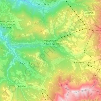
Name: Topografische Karte Welschnofen - Nova Levante, Höhe, Relief.
Durchschnittliche Höhe: 1.535 m
Minimale Höhe: 741 m
Maximale Höhe: 2.819 m
Andere topografische Karten
Klicken Sie auf eine Karte, um ihre Topografie, ihre Höhe und ihr Relief anzuzeigen.
Moos - Moso
Italy > Trentino – Alto Adige/Südtirol > South Tyrol
Moos - Moso, Sexten - Sesto, Pustertal - Val Pusteria, South Tyrol, Trentino – Alto Adige/Südtirol, 39030, Italy
Durchschnittliche Höhe: 1.607 m
Santa Cristina Gherdëina - St. Christina in Gröden - Santa Cristina Valgardena
Italy > Trentino – Alto Adige/Südtirol > South Tyrol
Santa Cristina Gherdëina - St. Christina in Gröden - Santa Cristina Valgardena, Salten-Schlern - Salto-Sciliar, South Tyrol, Trentino – Alto Adige/Südtirol, 39047, Italy
Durchschnittliche Höhe: 1.935 m