
Topografische Karte Dothan
Interaktive Karte
Klicken Sie auf die Karte, um die Höhe anzuzeigen.
Über diese Karte
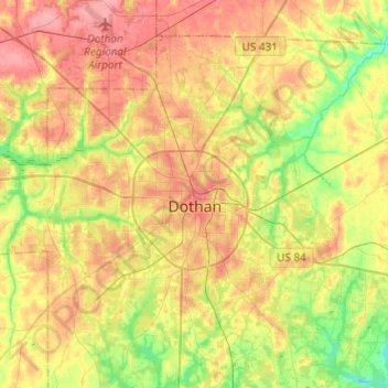
Name: Topografische Karte Dothan, Höhe, Relief.
Ort: Dothan, Houston County, Alabama, United States (31.12622 -85.51967 31.33397 -85.29409)
Durchschnittliche Höhe: 88 m
Minimale Höhe: 48 m
Maximale Höhe: 124 m
Andere topografische Karten
Klicken Sie auf eine Karte, um ihre Topografie, ihre Höhe und ihr Relief anzuzeigen.
Sherwood Forest
United States > Alabama > Houston County > Dothan
Sherwood Forest, Dothan, Houston County, Alabama, 36303, United States
Durchschnittliche Höhe: 97 m
Rock Creek Park
United States > Alabama > Houston County > Dothan
Rock Creek Park, Dothan, Houston County, Alabama, 36303, United States
Durchschnittliche Höhe: 91 m
Dothan
United States > Alabama > Houston County > Dothan
Dothan, Houston County, Alabama, 36303-5834, United States
Durchschnittliche Höhe: 83 m