
Topografische Karte Jaipur Municipal Corporation
Interaktive Karte
Klicken Sie auf die Karte, um die Höhe anzuzeigen.
Über diese Karte
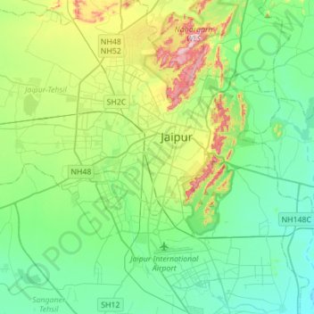
Name: Topografische Karte Jaipur Municipal Corporation, Höhe, Relief.
Ort: Jaipur Municipal Corporation, Jaipur Tehsil, Rajasthan, India (26.77469 75.68876 27.02187 75.91182)
Durchschnittliche Höhe: 411 m
Minimale Höhe: 331 m
Maximale Höhe: 647 m
Andere topografische Karten
Klicken Sie auf eine Karte, um ihre Topografie, ihre Höhe und ihr Relief anzuzeigen.
Amer
India > Rajasthan > Jaipur Municipal Corporation > Amer
Amer, Jaipur Municipal Corporation, Amber Tehsil, Jaipur, Rajasthan, 303101, India
Durchschnittliche Höhe: 468 m
Man Sagar
India > Rajasthan > Jaipur Municipal Corporation
Man Sagar, Amer Road, Brahmapuri, Bani Park, Jaipur Municipal Corporation, Jaipur Tehsil, Jaipur, Rajasthan, 302006, India
Durchschnittliche Höhe: 443 m