
Spenden
Rüsten Sie sich für Ihr nächstes Abenteuer:
Als Amazon-Partner verdient diese Website an qualifizierten Käufen, ohne dass Ihnen zusätzliche Kosten entstehen.
Topografische Karte Mount Phillips
Klicken Sie auf die Karte, um die Höhe anzuzeigen.
Spenden
Rüsten Sie sich für Ihr nächstes Abenteuer:
Als Amazon-Partner verdient diese Website an qualifizierten Käufen, ohne dass Ihnen zusätzliche Kosten entstehen.
Über diese Karte
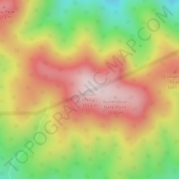
Name: Topografische Karte Mount Phillips, Höhe, Relief.
Ort: Mount Phillips, Colfax County, New Mexico, United States (36.47662 -105.15955 36.47672 -105.15945)
Durchschnittliche Höhe: 3.308 m
Minimale Höhe: 3.002 m
Maximale Höhe: 3.574 m
Spenden
Rüsten Sie sich für Ihr nächstes Abenteuer:
Als Amazon-Partner verdient diese Website an qualifizierten Käufen, ohne dass Ihnen zusätzliche Kosten entstehen.
Andere topografische Karten
Klicken Sie auf eine Karte, um ihre Topografie, ihre Höhe und ihr Relief anzuzeigen.
Angel Fire
United States > New Mexico > Colfax County
Angel Fire is located in southwestern Colfax County at 36°22′44″N 105°17′8″W / 36.37889°N 105.28556°W / 36.37889; -105.28556 (36.378808, -105.285658). The village center is in the valley of Cieneguilla Creek, with housing developments climbing mountain slopes to the east and west. Angel…
Durchschnittliche Höhe: 2.786 m
Raton
United States > New Mexico > Colfax County
Sugarite Canyon State Park is located 12 miles (19 km) northeast of Raton at an elevation of 8,800 feet (2,700 m). Activities there include camping, fishing, and hiking.
Durchschnittliche Höhe: 2.040 m
Spenden
Rüsten Sie sich für Ihr nächstes Abenteuer:
Als Amazon-Partner verdient diese Website an qualifizierten Käufen, ohne dass Ihnen zusätzliche Kosten entstehen.
Lake Maloya
United States > New Mexico > Colfax County
Lake Maloya is a reservoir in Sugarite Canyon State Park on the New Mexico-Colorado State border, northeast of Raton, New Mexico. It is the main source of water for the city and its outlying areas. When full, the lake's surface has an elevation of 7,516 feet (2,291 meters).
Durchschnittliche Höhe: 2.387 m
Angel Fire
United States > New Mexico > Colfax County
Angel Fire is located in southwestern Colfax County. The village center is in the valley of Cieneguilla Creek, with housing developments climbing mountain slopes to the east and west. Angel Fire Resort, entirely within the village limits, is on the east side of the valley, with a base elevation of 8,600 feet…
Durchschnittliche Höhe: 2.786 m
Spenden
Rüsten Sie sich für Ihr nächstes Abenteuer:
Als Amazon-Partner verdient diese Website an qualifizierten Käufen, ohne dass Ihnen zusätzliche Kosten entstehen.
Angel Fire
United States > New Mexico > Colfax County
Angel Fire is located in southwestern Colfax County. The village center is in the valley of Cieneguilla Creek, with housing developments climbing mountain slopes to the east and west. Angel Fire Resort, entirely within the village limits, is on the east side of the valley, with a base elevation of 8,600 feet…
Durchschnittliche Höhe: 2.786 m
Lake Maloya
United States > New Mexico > Colfax County
Lake Maloya is a reservoir in Sugarite Canyon State Park on the New Mexico-Colorado State border, northeast of Raton, New Mexico. It is the main source of water for the city and its outlying areas. When full, the lake's surface has an elevation of 7,516 feet (2,291 meters).
Durchschnittliche Höhe: 2.387 m