
Topografische Karte Loma
Interaktive Karte
Klicken Sie auf die Karte, um die Höhe anzuzeigen.
Über diese Karte
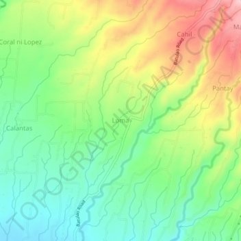
Name: Topografische Karte Loma, Höhe, Relief.
Ort: Loma, Calaca, Batangas, Calabarzon, 4212, Philippines (13.95212 120.77496 13.99212 120.81496)
Durchschnittliche Höhe: 110 m
Minimale Höhe: 35 m
Maximale Höhe: 224 m
Andere topografische Karten
Klicken Sie auf eine Karte, um ihre Topografie, ihre Höhe und ihr Relief anzuzeigen.
Salong
Philippines > Batangas > Calaca
Salong, Calaca, Batangas, Calabarzon, 4212, Philippines
Durchschnittliche Höhe: 22 m
Bambang
Philippines > Batangas > Calaca
Bambang, Calaca, Batangas, Calabarzon, 4212, Philippines
Durchschnittliche Höhe: 357 m
Cahil
Philippines > Batangas > Calaca
Cahil, Calaca, Batangas, Calabarzon, Philippines
Durchschnittliche Höhe: 177 m
Bagong Tubig
Philippines > Batangas > Calaca
Bagong Tubig, Calaca, Batangas, Calabarzon, 4212, Philippines
Durchschnittliche Höhe: 36 m
Puting Bato West
Philippines > Batangas > Calaca
Puting Bato West, Calaca, Batangas, Calabarzon, 4209, Philippines
Durchschnittliche Höhe: 25 m
Mount Batulao
Philippines > Batangas > Calaca
Mount Batulao, Calaca, Batangas, Calabarzon, 4212, Philippines
Durchschnittliche Höhe: 513 m
Balimbing
Philippines > Batangas > Calaca
Balimbing, Calaca, Batangas, Calabarzon, Philippines
Durchschnittliche Höhe: 336 m