
Topografische Karte Vale
Interaktive Karte
Klicken Sie auf die Karte, um die Höhe anzuzeigen.
Über diese Karte
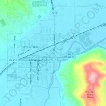
Name: Topografische Karte Vale, Höhe, Relief.
Ort: Vale, Malheur County, Oregon, United States (43.97467 -117.25552 43.99298 -117.21592)
Durchschnittliche Höhe: 710 m
Minimale Höhe: 677 m
Maximale Höhe: 897 m
According to the United States Census Bureau, the city has a total area of 1.14 square miles (2.95 km2), all of it land. The city has an elevation of 2,244 feet (684 m) above sea level.
Andere topografische Karten
Klicken Sie auf eine Karte, um ihre Topografie, ihre Höhe und ihr Relief anzuzeigen.
Owyhee River
United States > Oregon > Malheur County
Owyhee River, Malheur County, Oregon, United States
Durchschnittliche Höhe: 670 m
Beulah
United States > Oregon > Malheur County
Beulah, Malheur County, Oregon, United States
Durchschnittliche Höhe: 1.121 m
Snake River
United States > Oregon > Malheur County > Nyssa
Snake River, Nyssa, Malheur County, Oregon, United States
Durchschnittliche Höhe: 669 m
Jordan Valley
United States > Oregon > Malheur County
Jordan Valley, Malheur County, Oregon, 97910, United States
Durchschnittliche Höhe: 1.354 m
Cairo
United States > Oregon > Malheur County
Cairo, Malheur County, Oregon, United States
Durchschnittliche Höhe: 669 m
Harper
United States > Oregon > Malheur County
Harper, Malheur County, Oregon, 97906, United States
Durchschnittliche Höhe: 781 m
Nyssa
United States > Oregon > Malheur County
Nyssa, Malheur County, Oregon, 97913, United States
Durchschnittliche Höhe: 667 m
Rome
United States > Oregon > Malheur County
Rome, Malheur County, Oregon, United States
Durchschnittliche Höhe: 1.075 m
Ontario
United States > Oregon > Malheur County
Ontario, Malheur County, Oregon, 97914, United States
Durchschnittliche Höhe: 660 m