
Topografische Karte Madison
Interaktive Karte
Klicken Sie auf die Karte, um die Höhe anzuzeigen.
Über diese Karte
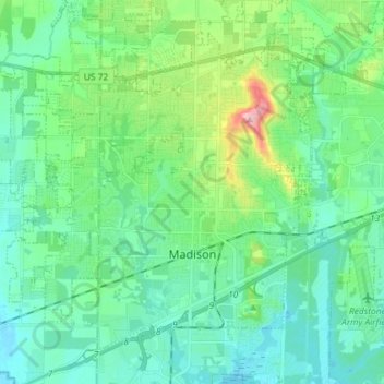
Name: Topografische Karte Madison, Höhe, Relief.
Ort: Madison, Madison County, Alabama, United States (34.66255 -86.85112 34.76543 -86.70602)
Durchschnittliche Höhe: 210 m
Minimale Höhe: 171 m
Maximale Höhe: 349 m
Andere topografische Karten
Klicken Sie auf eine Karte, um ihre Topografie, ihre Höhe und ihr Relief anzuzeigen.
Weatherly Heights
United States > Alabama > Madison County > Huntsville
Weatherly Heights, Huntsville, Madison County, Alabama, 35803, United States
Durchschnittliche Höhe: 197 m
Camelot
United States > Alabama > Madison County > Huntsville
Camelot, Huntsville, Madison County, Alabama, 35803, United States
Durchschnittliche Höhe: 269 m
Huntsville
United States > Alabama > Madison County
Huntsville, Madison County, Alabama, United States
Durchschnittliche Höhe: 232 m
Oak Park
United States > Alabama > Madison County > Huntsville
Oak Park, Huntsville, Madison County, Alabama, 35801, United States
Durchschnittliche Höhe: 281 m
Gurley
United States > Alabama > Madison County
Gurley, Madison County, Alabama, United States
Durchschnittliche Höhe: 234 m
South Gate
United States > Alabama > Madison County > Huntsville > South Gate
South Gate, Huntsville, Madison County, Alabama, 35803, United States
Durchschnittliche Höhe: 200 m