
Topografische Karte Indigo Run
Interaktive Karte
Klicken Sie auf die Karte, um die Höhe anzuzeigen.
Über diese Karte
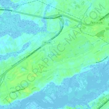
Name: Topografische Karte Indigo Run, Höhe, Relief.
Durchschnittliche Höhe: 5 m
Minimale Höhe: -5 m
Maximale Höhe: 14 m
Andere topografische Karten
Klicken Sie auf eine Karte, um ihre Topografie, ihre Höhe und ihr Relief anzuzeigen.
Port Royal
United States > South Carolina > Beaufort County > Hilton Head Island
Port Royal, Hilton Head Island, Beaufort County, South Carolina, United States
Durchschnittliche Höhe: 3 m
Sea Pines
United States > South Carolina > Beaufort County > Hilton Head Island
Sea Pines, Hilton Head Island, Beaufort County, South Carolina, 29938, United States
Durchschnittliche Höhe: 4 m
Coligny
United States > South Carolina > Beaufort County > Hilton Head Island
Coligny, Hilton Head Island, Beaufort County, South Carolina, 29928, United States
Durchschnittliche Höhe: 3 m
Hilton Head Plantation
United States > South Carolina > Beaufort County > Hilton Head Island > Hilton Head Plantation
Hilton Head Plantation, Hilton Head Island, Beaufort County, South Carolina, 29926, United States
Durchschnittliche Höhe: 6 m