
Topografische Karte Houlton
Interaktive Karte
Klicken Sie auf die Karte, um die Höhe anzuzeigen.
Über diese Karte
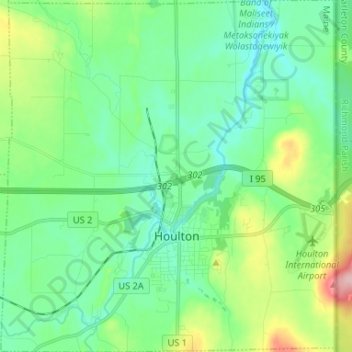
Name: Topografische Karte Houlton, Höhe, Relief.
Ort: Houlton, Aroostook County, Maine, 04730, United States (46.09511 -67.90656 46.18619 -67.78123)
Durchschnittliche Höhe: 133 m
Minimale Höhe: 89 m
Maximale Höhe: 263 m
Andere topografische Karten
Klicken Sie auf eine Karte, um ihre Topografie, ihre Höhe und ihr Relief anzuzeigen.
Weston
United States > Maine > Aroostook County
Weston, Aroostook County, Maine, 04424, United States
Durchschnittliche Höhe: 150 m
Limestone
United States > Maine > Aroostook County
Limestone, Aroostook County, Maine, United States
Durchschnittliche Höhe: 198 m
Van Buren
United States > Maine > Aroostook County
Van Buren, Aroostook County, Maine, 04785, United States
Durchschnittliche Höhe: 198 m
Hodgdon
United States > Maine > Aroostook County
Hodgdon, Aroostook County, Maine, United States
Durchschnittliche Höhe: 162 m
Presque Isle
United States > Maine > Aroostook County
Presque Isle, Aroostook County, Maine, 04769, United States
Durchschnittliche Höhe: 180 m
Reed Plantation
United States > Maine > Aroostook County
Reed Plantation, Aroostook County, Maine, United States
Durchschnittliche Höhe: 141 m
Winterville Plantation
United States > Maine > Aroostook County
Winterville Plantation, Aroostook County, Maine, United States
Durchschnittliche Höhe: 258 m
Linneus
United States > Maine > Aroostook County
Linneus, Aroostook County, Maine, United States
Durchschnittliche Höhe: 179 m
Castle Hill
United States > Maine > Aroostook County
Castle Hill, Aroostook County, Maine, United States
Durchschnittliche Höhe: 216 m
Eagle Lake
United States > Maine > Aroostook County
Eagle Lake, Aroostook County, Maine, 04739, United States
Durchschnittliche Höhe: 261 m
Frenchville
United States > Maine > Aroostook County
Frenchville, Aroostook County, Maine, 04745, United States
Durchschnittliche Höhe: 252 m
Ashland
United States > Maine > Aroostook County
Ashland, Aroostook County, Maine, United States
Durchschnittliche Höhe: 210 m
Mars Hill
United States > Maine > Aroostook County
Mars Hill, Aroostook County, Maine, 04758, United States
Durchschnittliche Höhe: 199 m
Littleton
United States > Maine > Aroostook County > Littleton
Littleton, Aroostook County, Maine, United States
Durchschnittliche Höhe: 140 m
Caribou
United States > Maine > Aroostook County
Caribou, Aroostook County, Maine, 04736, United States
Durchschnittliche Höhe: 181 m
Allagash
United States > Maine > Aroostook County
Allagash, Aroostook County, Maine, 04774, United States
Durchschnittliche Höhe: 311 m