Geolokalisieren

Topografische Karte Belta

Interaktive Karte

Klicken Sie auf die Karte, um die Höhe anzuzeigen.

Über diese Karte

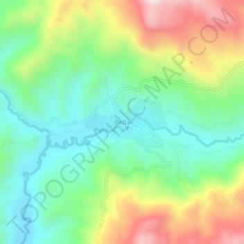
Name: Topografische Karte Belta, Höhe, Relief.

Ort: Belta, Gamo Gofa, Southern Nations, Nationalities, and Peoples, Ethiopia (6.04653 37.25266 6.08653 37.29266)

Durchschnittliche Höhe: 2.613 m

Minimale Höhe: 2.372 m

Maximale Höhe: 3.034 m

Andere topografische Karten

Klicken Sie auf eine Karte, um ihre Topografie, ihre Höhe und ihr Relief anzuzeigen.

Butajira

Ethiopia > Southern Nations, Nationalities, and Peoples

Butajira, Guraghe, Southern Nations, Nationalities, and Peoples, Ethiopia

Durchschnittliche Höhe: 2.078 m

Nech Sar National Park

Ethiopia > Southern Nations, Nationalities, and Peoples > Arba Minch

Nech Sar National Park, Arba Minch, Gamo Gofa, Southern Nations, Nationalities, and Peoples, Ethiopia

Durchschnittliche Höhe: 1.215 m

Kore

Ethiopia > Southern Nations, Nationalities, and Peoples > Nili

Kore, Nili, South Omo, Southern Nations, Nationalities, and Peoples, Ethiopia

Durchschnittliche Höhe: 544 m

Gamo Gofa

Ethiopia > Southern Nations, Nationalities, and Peoples

Gamo Gofa, Southern Nations, Nationalities, and Peoples, Ethiopia

Durchschnittliche Höhe: 1.502 m

Southern Nations, Nationalities, and Peoples

Ethiopia > Southern Nations, Nationalities, and Peoples

Southern Nations, Nationalities, and Peoples, Ethiopia

Durchschnittliche Höhe: 1.382 m