
Topografische Karte Praia da Alagoa
Interaktive Karte
Klicken Sie auf die Karte, um die Höhe anzuzeigen.
Über diese Karte
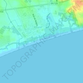
Name: Topografische Karte Praia da Alagoa, Höhe, Relief.
Ort: Praia da Alagoa, Altura, Castro Marim, Faro, Portugal (37.16690 -7.50643 37.17206 -7.48972)
Durchschnittliche Höhe: 5 m
Minimale Höhe: 0 m
Maximale Höhe: 41 m
Andere topografische Karten
Klicken Sie auf eine Karte, um ihre Topografie, ihre Höhe und ihr Relief anzuzeigen.
Praia Verde
Portugal > Faro > Castro Marim
Praia Verde, Castro Marim, Faro, Portugal
Durchschnittliche Höhe: 7 m
Alta Mora
Portugal > Faro > Castro Marim
Alta Mora, Castro Marim, Faro, Portugal
Durchschnittliche Höhe: 192 m
Azinhal
Portugal > Faro > Castro Marim
Azinhal, Castro Marim, Faro, 8950-032, Portugal
Durchschnittliche Höhe: 65 m
São Bartolomeu
Portugal > Faro > Castro Marim
São Bartolomeu, Castro Marim, Faro, 8950-256, Portugal
Durchschnittliche Höhe: 17 m
Odeleite
Portugal > Faro > Castro Marim
Odeleite, Castro Marim, Faro, Portugal
Durchschnittliche Höhe: 90 m
Praia do Cabeço
Portugal > Faro > Castro Marim
Praia do Cabeço, Castro Marim, Faro, Portugal
Durchschnittliche Höhe: 7 m