
Topografische Karte Magnetawan
Klicken Sie auf die Karte, um die Höhe anzuzeigen.
Über diese Karte
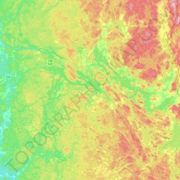
Name: Topografische Karte Magnetawan, Höhe, Relief.
Durchschnittliche Höhe: 310 m
Minimale Höhe: 236 m
Maximale Höhe: 411 m
Andere topografische Karten
Klicken Sie auf eine Karte, um ihre Topografie, ihre Höhe und ihr Relief anzuzeigen.
Diamond Lake
Canada > Ontario > Parry Sound District > Seguin Township > Orrville
Durchschnittliche Höhe: 273 m
Lake Bernard
Canada > Ontario > Parry Sound District > Strong Township > Sundridge
Durchschnittliche Höhe: 347 m
Moon River
Canada > Ontario > Parry Sound District > The Archipelago Township
Durchschnittliche Höhe: 185 m
Pickerel River
Canada > Ontario > Parry Sound District > Unorganized Centre Parry Sound
Durchschnittliche Höhe: 200 m
Dokis Island
Canada > Ontario > Parry Sound District > Unorganized Centre Parry Sound
Durchschnittliche Höhe: 196 m
Port Loring
Canada > Ontario > Parry Sound District > Unorganized Centre Parry Sound
Durchschnittliche Höhe: 227 m
Restoule
Canada > Ontario > Parry Sound District > Unorganized Centre Parry Sound
Durchschnittliche Höhe: 237 m
Pointe au Baril
Canada > Ontario > Parry Sound District > The Archipelago Township
Durchschnittliche Höhe: 177 m
Dollars Lake
Canada > Ontario > Parry Sound District > Unorganized Centre Parry Sound
Durchschnittliche Höhe: 215 m
Dillon's Cove
Canada > Ontario > Parry Sound District > Carling Township
Durchschnittliche Höhe: 179 m
Stormy Lake
Canada > Ontario > Parry Sound District > Unorganized Centre Parry Sound
Durchschnittliche Höhe: 227 m
Arnstein
Canada > Ontario > Parry Sound District > Unorganized Centre Parry Sound
Durchschnittliche Höhe: 233 m
Ferguson Island
Canada > Ontario > Parry Sound District > Unorganized Centre Parry Sound
Durchschnittliche Höhe: 206 m
Manitouwabing Lake
Canada > Ontario > Parry Sound District > McKellar Township > McKellar
Durchschnittliche Höhe: 249 m
Whistler Bay
Canada > Ontario > Parry Sound District > Unorganized Centre Parry Sound
Durchschnittliche Höhe: 178 m
Key River
Canada > Ontario > Parry Sound District > Unorganized Centre Parry Sound
Durchschnittliche Höhe: 193 m
Sundridge
Canada > Ontario > Parry Sound District > Strong Township > Sundridge
Durchschnittliche Höhe: 355 m
Moon River
Canada > Ontario > Parry Sound District > The Archipelago Township
Durchschnittliche Höhe: 185 m
Nipissing
Canada > Ontario > Parry Sound District > Nipissing Township > Nipissing
Durchschnittliche Höhe: 227 m
Recollet Falls
Canada > Ontario > Parry Sound District > Unorganized Centre Parry Sound
Durchschnittliche Höhe: 206 m
Orrville
Canada > Ontario > Parry Sound District > Seguin Township > Orrville
Durchschnittliche Höhe: 262 m
Magnetawan River
Canada > Ontario > Parry Sound District > Unorganized Centre Parry Sound
Durchschnittliche Höhe: 198 m
Fairfield Island
Canada > Ontario > Parry Sound District > Carling Township
Durchschnittliche Höhe: 199 m
Key Harbour
Canada > Ontario > Parry Sound District > Unorganized Centre Parry Sound
Durchschnittliche Höhe: 178 m
Cole Lake
Canada > Ontario > Parry Sound District > Unorganized Centre Parry Sound
Durchschnittliche Höhe: 216 m
Conger Lake
Canada > Ontario > Parry Sound District > The Archipelago Township
Durchschnittliche Höhe: 200 m
Deer Horn Island
Canada > Ontario > Parry Sound District > The Archipelago Township
Durchschnittliche Höhe: 199 m
Richardson Island
Canada > Ontario > Parry Sound District > Nipissing Township
Durchschnittliche Höhe: 194 m
Key River
Canada > Ontario > Parry Sound District > Unorganized Centre Parry Sound
Durchschnittliche Höhe: 194 m
Bosworth Island
Canada > Ontario > Parry Sound District > Unorganized Centre Parry Sound
Durchschnittliche Höhe: 224 m
Doe Lake
Canada > Ontario > Parry Sound District > McMurrich/Monteith Township
Durchschnittliche Höhe: 303 m
Culin Lake
Canada > Ontario > Parry Sound District > Unorganized Centre Parry Sound > Arnstein
Durchschnittliche Höhe: 230 m
Bob's Lake
Canada > Ontario > Parry Sound District > Unorganized Centre Parry Sound
Durchschnittliche Höhe: 255 m
Memesagamesing Lake Dam
Canada > Ontario > Parry Sound District > Unorganized Centre Parry Sound
Durchschnittliche Höhe: 227 m
Dollars Lake
Canada > Ontario > Parry Sound District > Unorganized Centre Parry Sound
Durchschnittliche Höhe: 215 m
Jack's Ridge
Canada > Ontario > Parry Sound District > Unorganized Centre Parry Sound
Durchschnittliche Höhe: 254 m
Oastler Lake Provincial Park
Canada > Ontario > Parry Sound District > Seguin Township
Durchschnittliche Höhe: 218 m
Loring
Canada > Ontario > Parry Sound District > Unorganized Centre Parry Sound
Durchschnittliche Höhe: 241 m
Magnetawan
Canada > Ontario > Parry Sound District > Magnetawan > Magnetawan
Durchschnittliche Höhe: 296 m
Smith Bay
Canada > Ontario > Parry Sound District > Unorganized Centre Parry Sound
Durchschnittliche Höhe: 217 m
Watt Island
Canada > Ontario > Parry Sound District > The Archipelago Township
Durchschnittliche Höhe: 195 m
Clear Lake
Canada > Ontario > Parry Sound District > Unorganized Centre Parry Sound
Durchschnittliche Höhe: 222 m
McNeil's Island
Canada > Ontario > Parry Sound District > Unorganized Centre Parry Sound > Port Loring
Durchschnittliche Höhe: 213 m
Skye Island
Canada > Ontario > Parry Sound District > The Archipelago Township
Durchschnittliche Höhe: 191 m
Sprucedale
Canada > Ontario > Parry Sound District > McMurrich/Monteith Township
Durchschnittliche Höhe: 330 m
Hooper Island
Canada > Ontario > Parry Sound District > Carling Township
Durchschnittliche Höhe: 193 m
Rye
Canada > Ontario > Parry Sound District > Unorganized Centre Parry Sound
Durchschnittliche Höhe: 344 m
Stirling Falls
Canada > Ontario > Parry Sound District > Strong Township
Durchschnittliche Höhe: 335 m
Jack's Ridge
Canada > Ontario > Parry Sound District > Unorganized Centre Parry Sound
Durchschnittliche Höhe: 254 m
Magee Island
Canada > Ontario > Parry Sound District > Unorganized Centre Parry Sound
Durchschnittliche Höhe: 196 m
Stalker Island
Canada > Ontario > Parry Sound District > Carling Township
Durchschnittliche Höhe: 188 m
Jack's Ridge
Canada > Ontario > Parry Sound District > Unorganized Centre Parry Sound
Durchschnittliche Höhe: 254 m