
Spenden
Rüsten Sie sich für Ihr nächstes Abenteuer:
Als Amazon-Partner verdient diese Website an qualifizierten Käufen, ohne dass Ihnen zusätzliche Kosten entstehen.
Topografische Karte Jawbone
Klicken Sie auf die Karte, um die Höhe anzuzeigen.
Spenden
Rüsten Sie sich für Ihr nächstes Abenteuer:
Als Amazon-Partner verdient diese Website an qualifizierten Käufen, ohne dass Ihnen zusätzliche Kosten entstehen.
Über diese Karte
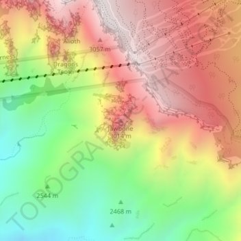
Name: Topografische Karte Jawbone, Höhe, Relief.
Ort: Jawbone, Bernalillo County, New Mexico, United States (35.18920 -106.43606 35.18930 -106.43596)
Durchschnittliche Höhe: 2.706 m
Minimale Höhe: 2.223 m
Maximale Höhe: 3.151 m
Spenden
Rüsten Sie sich für Ihr nächstes Abenteuer:
Als Amazon-Partner verdient diese Website an qualifizierten Käufen, ohne dass Ihnen zusätzliche Kosten entstehen.
Andere topografische Karten
Klicken Sie auf eine Karte, um ihre Topografie, ihre Höhe und ihr Relief anzuzeigen.
Albuquerque
United States > New Mexico > Bernalillo County
Located in north-central New Mexico, Albuquerque serves as the county seat of Bernalillo County. To its east are the Sandia–Manzano Mountains, Rio Grande flows north to south through its center, while the West Mesa and Petroglyph National Monument make up the western part of the city. Albuquerque has one of…
Durchschnittliche Höhe: 1.687 m
Albuquerque
United States > New Mexico > Bernalillo County
Albuquerque features a striking topography characterized by its elevation and diverse geological formations. The city sits at an approximate elevation of 4,900 feet (1,500 meters) near the Rio Grande, rising dramatically to over 6,700 feet (2,000 meters) in the foothills of the nearby Sandia Mountains. These…
Durchschnittliche Höhe: 1.687 m
Rio Grande
United States > New Mexico > Bernalillo County > South Valley
Durchschnittliche Höhe: 1.504 m
Spenden
Rüsten Sie sich für Ihr nächstes Abenteuer:
Als Amazon-Partner verdient diese Website an qualifizierten Käufen, ohne dass Ihnen zusätzliche Kosten entstehen.
Los Ranchos de Albuquerque
United States > New Mexico > Bernalillo County
Durchschnittliche Höhe: 1.524 m
Sandia Mountain Wilderness
United States > New Mexico > Bernalillo County > Cedar Crest
Some of the most common animals seen in the Sandia Wilderness are mule deer, black bears, raccoons, bobcats, and various species of squirrel. There are also many birds of prey that live and migrate within the Sandia Mountain Wilderness including golden eagles and various species of hawks. Other birds such as…
Durchschnittliche Höhe: 2.051 m
Central Pond (Tingley Beach)
United States > New Mexico > Bernalillo County > Albuquerque
Durchschnittliche Höhe: 1.511 m
Spenden
Rüsten Sie sich für Ihr nächstes Abenteuer:
Als Amazon-Partner verdient diese Website an qualifizierten Käufen, ohne dass Ihnen zusätzliche Kosten entstehen.
Albuquerque
United States > New Mexico > Bernalillo County
Albuquerque is located in north-central New Mexico. To its east are the Sandia–Manzano Mountains. The Rio Grande flows north to south through its center, while the West Mesa and Petroglyph National Monument make up the western part of the city. Albuquerque has one of the highest elevations of any major city…
Durchschnittliche Höhe: 1.688 m
South Valley
United States > New Mexico > Bernalillo County > Albuquerque
Durchschnittliche Höhe: 1.552 m
Los Ranchos de Albuquerque
United States > New Mexico > Bernalillo County
Durchschnittliche Höhe: 1.524 m
Spenden
Rüsten Sie sich für Ihr nächstes Abenteuer:
Als Amazon-Partner verdient diese Website an qualifizierten Käufen, ohne dass Ihnen zusätzliche Kosten entstehen.
Rio Grande
United States > New Mexico > Bernalillo County > South Valley
Durchschnittliche Höhe: 1.504 m
Albuquerque
United States > New Mexico > Bernalillo County
Albuquerque is located in north-central New Mexico. To its east are the Sandia–Manzano Mountains. The Rio Grande flows north to south through its center, while the West Mesa and Petroglyph National Monument make up the western part of the city. Albuquerque has one of the highest elevations of any major city…
Durchschnittliche Höhe: 1.687 m
Spenden
Rüsten Sie sich für Ihr nächstes Abenteuer:
Als Amazon-Partner verdient diese Website an qualifizierten Käufen, ohne dass Ihnen zusätzliche Kosten entstehen.
Joe M. Lucero Hillside
United States > New Mexico > Bernalillo County > Albuquerque
Durchschnittliche Höhe: 1.637 m